

| Mesoscale Discussion 2073 | |
| < Previous MD | |
|
|
   Mesoscale Discussion 2073
   NWS Storm Prediction Center Norman OK
   0438 PM CDT Fri Aug 21 2026

   Areas affected...Parts of southwest South Dakota and western
   Nebraska

   Concerning...Severe potential...Watch possible

   Valid 212138Z - 220015Z

   Probability of Watch Issuance...60 percent

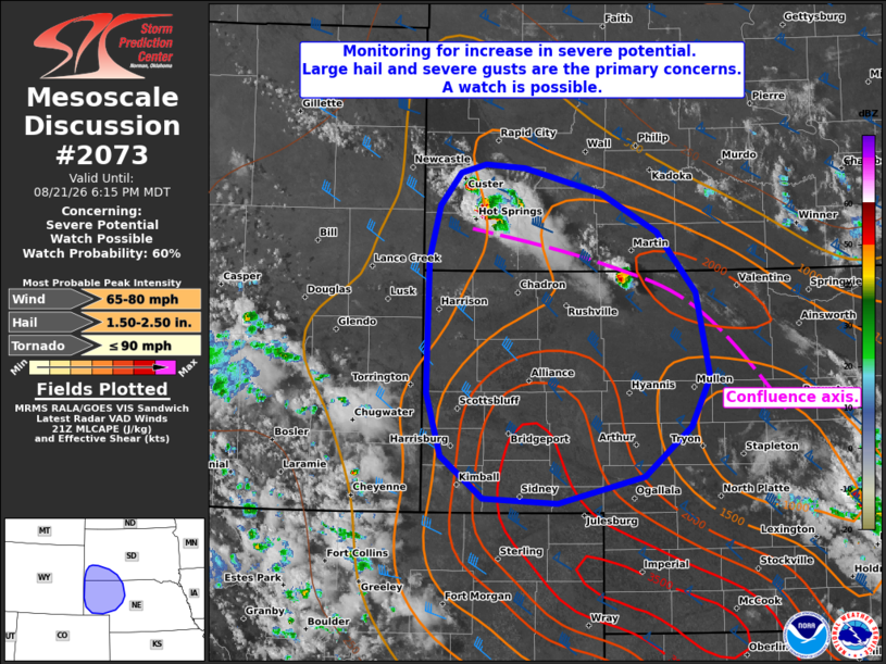
   SUMMARY...The area is being monitored for an increase in
   severe-thunderstorm potential. The primary concerns are large hail
   and severe wind gusts. A watch issuance is possible.

   DISCUSSION...Isolated thunderstorms are evolving along a
   SE/NW-oriented confluence axis extending from parts of northwest NE
   toward the Black Hills. This activity is potentially being aided by
   a subtle midlevel impulse cresting the ridge in the northern Plains.
   The UNR 18Z sounding sampled steep deep-layer lapse rates and a
   long/mostly straight hodograph (around 40 kt of effective shear) --
   which will support splitting supercell structures and organized
   clusters. The primary concern will be large hail and robust
   outflow/severe wind gusts. Given the subtle large-scale forcing for
   ascent and some lingering low-level inhibition, storm coverage is
   uncertain. Convective trends will be monitored in the near term, and
   a watch issuance is possible.

   ..Weinman/Thompson.. 08/21/2026

   ...Please see www.spc.noaa.gov for graphic product...

   ATTN...WFO...LBF...UNR...CYS...

   LAT...LON   41710107 41290158 41080255 41120337 41460384 41980401
               43100398 43530387 43800363 43880335 43850292 43630206
               43320144 42820100 42110085 41710107

   MOST PROBABLE PEAK TORNADO INTENSITY...UP TO 90 MPH
   MOST PROBABLE PEAK WIND GUST...65-80 MPH
   MOST PROBABLE PEAK HAIL SIZE...1.50-2.50 IN
|
|
|
Top/All Mesoscale Discussions/Forecast Products/Home |
|
Source link