

| Mesoscale Discussion 2072 | |
| < Previous MD | |
|
|
   Mesoscale Discussion 2072
   NWS Storm Prediction Center Norman OK
   0335 PM CDT Fri Aug 21 2026

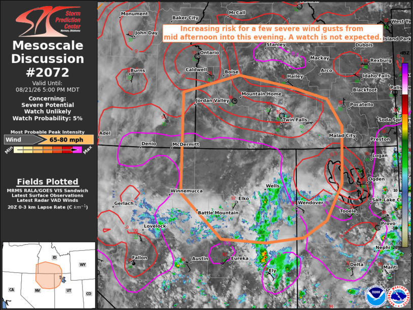
   Areas affected...north-central and northeast Nevada...northwest
   Utah...far southeast Oregon...and southern Idaho.

   Concerning...Severe potential...Watch unlikely

   Valid 212035Z - 212300Z

   Probability of Watch Issuance...5 percent

   SUMMARY...The threat for a few severe wind gusts up to 70-80 mph is
   expected to increase by mid to late afternoon. A watch is not
   expected due to the isolated nature of the threat.

   DISCUSSION...Subtle mid-level disturbances embedded in a moist,
   southerly flow regime are contributing to a gradual increase in
   thunderstorms this afternoon across portions of central and southern
   NV. Modification of the 18Z LKN sounding for hotter surface
   conditions currently observed over northeast NV into northwest UT
   yields MUCAPE of 500-750 J/kg atop a 3-4 km deep, well-mixed
   boundary layer. As such, thunderstorms are expected to move/develop
   north through the region this afternoon into evening with an
   associated risk for locally severe wind gusts up to 70-80 mph,
   driven by strong evaporational cooling potential in the sub-cloud
   layer. Explicit wind gust fields from the latest CAM data continue
   to highlight portions of north-central and northeast NV into
   southwest ID as a most likely corridor for the strongest gusts to
   occur.

   ..Mead/Smith.. 08/21/2026

   ...Please see www.spc.noaa.gov for graphic product...

   ATTN...WFO...SLC...PIH...BOI...LKN...

   LAT...LON   43221740 41011740 40001622 39931493 40041384 40401316
               41211270 42481266 43081310 43351414 43621572 43221740

   MOST PROBABLE PEAK WIND GUST...65-80 MPH
|
|
|
Top/All Mesoscale Discussions/Forecast Products/Home |
|
Source link