

| Mesoscale Discussion 2071 | |
| < Previous MD Next MD > | |

|
|
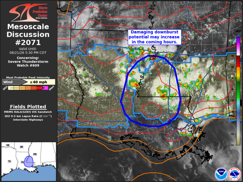
Mesoscale Discussion 2071 NWS Storm Prediction Center Norman OK 0333 PM CDT Fri Aug 21 2026 Areas affected...Lower Mississippi River Valley Concerning...Severe Thunderstorm Watch 609... Valid 212033Z - 212230Z The severe weather threat for Severe Thunderstorm Watch 609 continues. SUMMARY...The potential for damaging winds will continue through late afternoon across the lower Mississippi River Valley. DISCUSSION...Regional radar imagery out of southern MS and eastern LA depicts poorly organized, and largely outflow-dominant, convection. These cells/clusters have been producing occasionally strong downbursts with velocity data depicting 40-50 knot outflow within the lowest 1-2 kft ARL. Additionally, surface stations that have been impacted by outflow have reported temperature reductions on the order of 20 F. Given these conditions within the convective cold pools and weak low-level shear sampled by regional VWPs, outflow boundaries should become more prominent within the next hour or so. Boundary collisions downstream across east/southeast LA will likely promote additional updraft development within a hot and unstable air mass (characterized by low-level lapse rates approaching 9 C/km and MLCAPE estimated to be around 2500-3000 J/kg). Intense downbursts will be possible with the more vigorous updraft pulses as additional convection develops and spreads south into this air mass over the next few hours. Given the thermodynamic conditions, embedded swaths of 45-60 mph appear possible within the strongest downbursts. ..Moore.. 08/21/2026 ...Please see www.spc.noaa.gov for graphic product... ATTN...WFO...JAN...LIX...LCH...SHV... LAT...LON 30859220 31719195 32069162 32249124 32259096 32169064 31869029 31359017 30909009 30529019 30369031 30189054 30109085 30119122 30159150 30269183 30499206 30859220 MOST PROBABLE PEAK WIND GUST...UP TO 60 MPH |
|
|
Top/All Mesoscale Discussions/Forecast Products/Home |
|
Source link