

| Mesoscale Discussion 2059 | |
| < Previous MD | |
|
|
   Mesoscale Discussion 2059
   NWS Storm Prediction Center Norman OK
   0713 PM CDT Thu Aug 20 2026

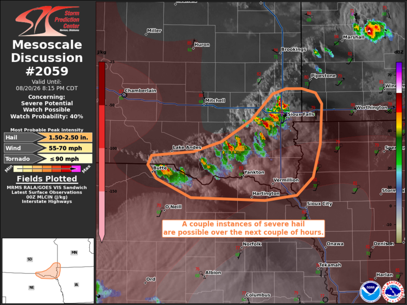
   Areas affected...portions of southeastern South Dakota to the
   Nebraska and Iowa borders

   Concerning...Severe potential...Watch possible

   Valid 210013Z - 210115Z

   Probability of Watch Issuance...40 percent

   SUMMARY...An isolated severe hail threat will persist for a few more
   hours. However, storms will move into stronger MLCINH, which may
   limit the spatial and temporal extent of the severe threat.

   DISCUSSION...Multiple splitting supercells have developed over the
   last couple of hours, with an instance of golfball hail recently
   reported on a storm in Minnehaha County, SD. These storms are
   benefiting from 3000+ J/kg MLCAPE and 50 kts of effective bulk shear
   in place. Nonetheless, these storms are also approaching a region of
   appreciable MLCINH. The current thinking is that these storms should
   gradually weaken as they move off of the surface trough/boundary and
   move into the inhibition. As such, while a few more instances of
   severe hail could occur, the severe threat should remain confined
   along the surface trough for just a few more hours.

   ..Squitieri/Guyer.. 08/21/2026

   ...Please see www.spc.noaa.gov for graphic product...

   ATTN...WFO...FSD...OAX...LBF...

   LAT...LON   42619823 42829877 42999891 43109886 43149818 43279774
               43529727 43839692 43899669 43889644 43849622 43709612
               43249616 42859627 42639654 42579705 42619823

   MOST PROBABLE PEAK TORNADO INTENSITY...UP TO 90 MPH
   MOST PROBABLE PEAK WIND GUST...55-70 MPH
   MOST PROBABLE PEAK HAIL SIZE...1.50-2.50 IN
|
|
|
Top/All Mesoscale Discussions/Forecast Products/Home |
|
Source link