

| Mesoscale Discussion 2057 | |
| < Previous MD | |

|
|
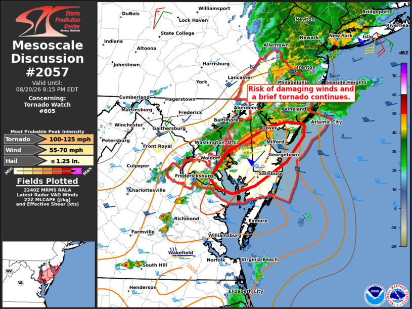
Mesoscale Discussion 2057 NWS Storm Prediction Center Norman OK 0542 PM CDT Thu Aug 20 2026 Areas affected...Parts of DelMarVa and far southern NJ Concerning...Tornado Watch 605... Valid 202242Z - 210015Z The severe weather threat for Tornado Watch 605 continues. SUMMARY...The risk of damaging wind gusts and a brief tornado continues across parts of Tornado Watch 605. DISCUSSION...A cluster of thunderstorms with an embedded supercell is tracking eastward into parts of the DE Bay. These storms will continue tracking eastward along a differential heating boundary and ahead of a frontal wave, where enhanced low-level vorticity along the boundary and a clockwise-curved low-level hodograph (around 250 m2/s2 0-1km SRH per DOX VWP) will continue to promote a risk of a tornado and damaging wind gusts into far southern NJ in the near term. Farther south, an increasingly organized line of storms is moving into a warm/moist air mass across DelMarVa. The associated strong surface-based buoyancy and around 40 kt of deep-layer shear oriented perpendicular to the evolving gust front will favor damaging wind gusts and possibly a brief/embedded tornado. ..Weinman.. 08/20/2026 ...Please see www.spc.noaa.gov for graphic product... ATTN...WFO...PHI...AKQ...LWX... LAT...LON 38797627 39237538 39317494 39277455 39067456 38617494 38207566 38067615 38177652 38337666 38797627 MOST PROBABLE PEAK TORNADO INTENSITY...100-125 MPH MOST PROBABLE PEAK WIND GUST...55-70 MPH MOST PROBABLE PEAK HAIL SIZE...UP TO 1.25 IN |
|
|
Top/All Mesoscale Discussions/Forecast Products/Home |
|
Source link