

| Mesoscale Discussion 2044 | |
| < Previous MD Next MD > | |
|
|
   Mesoscale Discussion 2044
   NWS Storm Prediction Center Norman OK
   0342 PM CDT Wed Aug 19 2026

   Areas affected...Northwest Kansas

   Concerning...Severe potential...Watch unlikely

   Valid 192042Z - 192245Z

   Probability of Watch Issuance...5 percent

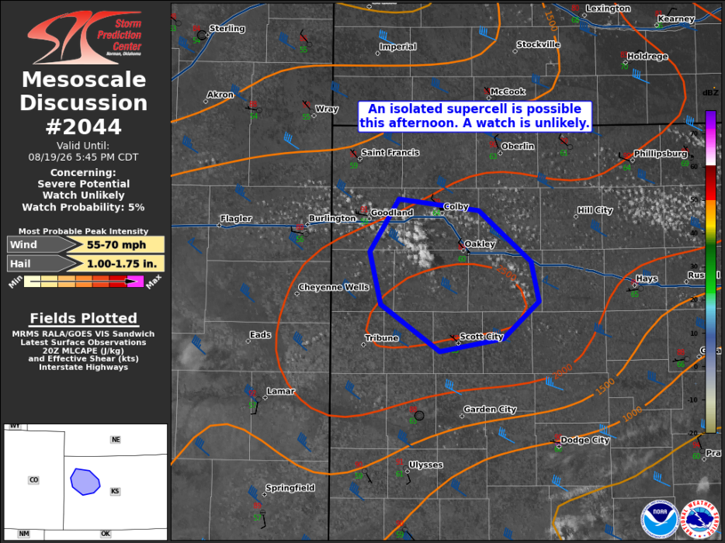
   SUMMARY...An isolated supercell appears possible based on recent
   satellite trends. Isolated large hail and severe winds are possible
   should a storm develop. A watch is not likely.

   DISCUSSION...An area of agitated cumulus has developed in northwest
   Kansas over the last hour along a weak surface cold front. Very weak
   ascent aloft from a glancing shortwave trough in the central Plains
   could allow an isolated supercell to develop. Visible satellite
   trends and some recent CAM guidance would suggest storm initiation
   is probable, though not certain. The environment would support
   isolated large hail and severe winds. Given the lack of greater
   upper-level support, coverage and duration of severe intensity will
   likely be limited.

   ..Wendt/Smith.. 08/19/2026

   ...Please see www.spc.noaa.gov for graphic product...

   ATTN...WFO...DDC...GLD...

   LAT...LON   38740159 39120170 39480144 39400072 39050024 38760017
               38510049 38410106 38740159

   MOST PROBABLE PEAK WIND GUST...55-70 MPH
   MOST PROBABLE PEAK HAIL SIZE...1.00-1.75 IN
|
|
|
Top/All Mesoscale Discussions/Forecast Products/Home |
|
Source link