

| Mesoscale Discussion 2039 | |
| < Previous MD | |

|
|
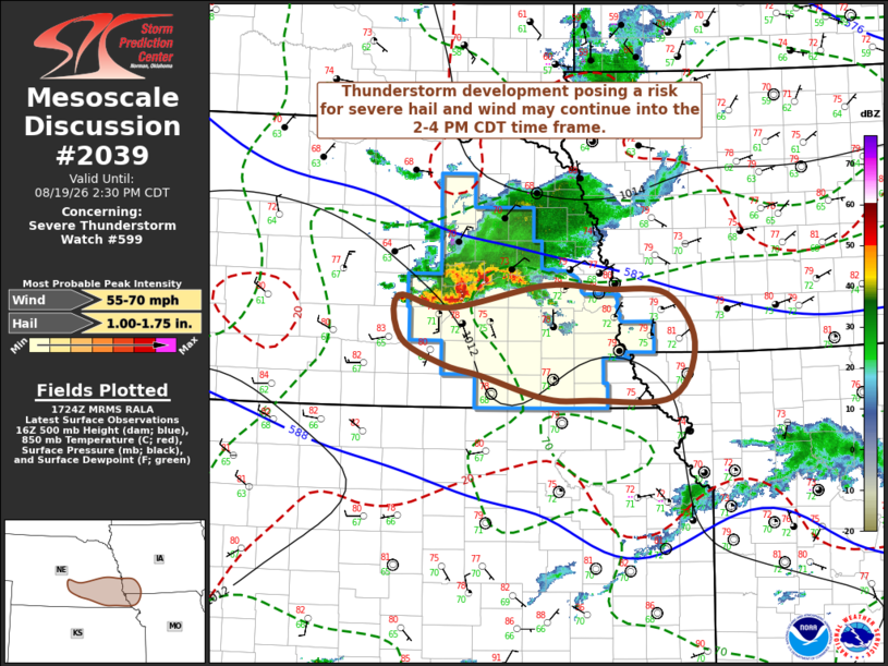
Mesoscale Discussion 2039 NWS Storm Prediction Center Norman OK 1226 PM CDT Wed Aug 19 2026 Areas affected...parts of south central/southeastern Nebraska adjacent southwestern Iowa and northwestern Missouri Concerning...Severe Thunderstorm Watch 599... Valid 191726Z - 191930Z The severe weather threat for Severe Thunderstorm Watch 599 continues. SUMMARY...The ongoing cluster of storms may continue to become less organized and weaken, but strong thunderstorm development posing a risk for severe hail and wind may continue into the 2-4 PM CDT time frame. DISCUSSION...A broader cyclonic vortex has evolved from an initial supercell structure over the past couple of hours, with stronger associated thunderstorm development maintaining a modest south-southeastward propagation. Subsequent evolution of this cluster remains uncertain, as latest Rapid Refresh continues to indicate weakening of initial lower/mid-tropospheric warm advection supporting forcing for ascent over the next couple of hours. As this occurs, increasing mid-level inhibition and less unstable inflow may contribute to diminishing convection on the south/southwestern flank of the cluster. A corridor of stronger destabilization (including CAPE on the order of 1500-2000 J/kg) has evolved downstream of the ongoing cluster, near/southwest of Omaha and south of I-80 into southwestern Iowa. This appears focused near the northern periphery of the elevated mixed-layer, as roughly depicted by the thermal gradient around 700 mb. This may shift southward a bit with continuing progression of the MCV within west-northwesterly mean flow, with forcing associated with the MCV and/or, perhaps, the associated surface cold pool supporting renewed convective development through 19-21Z. ..Kerr.. 08/19/2026 ...Please see www.spc.noaa.gov for graphic product... ATTN...WFO...DMX...EAX...OAX...GID... LAT...LON 41289685 41239601 41189518 40689480 40109513 40089624 40109685 40339771 40459825 40729884 41169887 41039817 41289685 MOST PROBABLE PEAK WIND GUST...55-70 MPH MOST PROBABLE PEAK HAIL SIZE...1.00-1.75 IN |
|
|
Top/All Mesoscale Discussions/Forecast Products/Home |
|
Source link