

| Mesoscale Discussion 2029 | |
| < Previous MD Next MD > | |
|
|
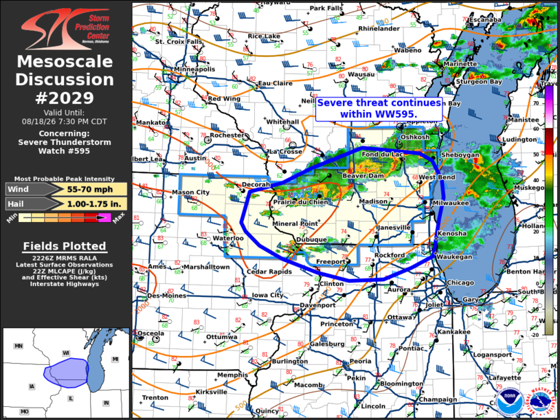
Mesoscale Discussion 2029 NWS Storm Prediction Center Norman OK 0529 PM CDT Tue Aug 18 2026 Areas affected...northeast Iowa...southern Wisconsin...northern Illinois Concerning...Severe Thunderstorm Watch 595... Valid 182229Z - 190030Z The severe weather threat for Severe Thunderstorm Watch 595 continues. SUMMARY...Severe threat continues within WW595. DISCUSSION...Thunderstorms across southern Wisconsin have taken on a more linear/bowing mode over the last hour. The line has produced a few instances of damaging wind, with measured gusts up to 61 mph. Deep layer flow is largely westerly, which will likely push the line eastward across southern Wisconsin through the evening with damaging wind becoming the main threat. Watch issuance further south of WW595 remains uncertain. Deep layer flow decreases further south, with mid-level cloud cover in place and less instability. Additionally, lapse rate profiles are meager. A couple of cells have developed further west across far eastern Iowa. These may pose some potential for large hail in the short term. It remains uncertain that coverage/duration will warrant additional watch issuance at this time but this area will be monitored. ..Thornton.. 08/18/2026 ...Please see www.spc.noaa.gov for graphic product... ATTN...WFO...GRB...LOT...MKX...DVN...ARX... LAT...LON 43269158 43409092 43629034 43948929 43858813 43738786 43448767 43188765 42868775 42328788 42148831 41988888 41958956 42079019 42289090 42469136 42679166 42819174 43269158 MOST PROBABLE PEAK WIND GUST...55-70 MPH MOST PROBABLE PEAK HAIL SIZE...1.00-1.75 IN |
|
|
Top/All Mesoscale Discussions/Forecast Products/Home |
|
Source link