

| Mesoscale Discussion 2028 | |
| < Previous MD | |
|
|
   Mesoscale Discussion 2028
   NWS Storm Prediction Center Norman OK
   0452 PM CDT Tue Aug 18 2026

   Areas affected...northern lower Michigan Peninsula

   Concerning...Severe potential...Watch possible

   Valid 182152Z - 182345Z

   Probability of Watch Issuance...40 percent

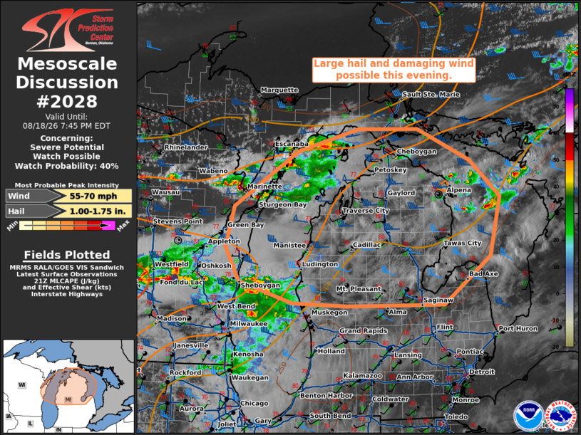
   SUMMARY...Large hail and damaging wind will be possible with
   isolated supercells this evening.

   DISCUSSION...Thunderstorm activity is shifting eastward across Lake
   Michigan this evening. Downstream, the air mass is only marginally
   unstable, with MLCAPE around 250-500 J/kg. Deep layer flow is
   seasonably strong, with deep layer shear 35-45 kts across the
   northern lower Michigan Peninsula. RAOB profiles from APX (Gaylord,
   MI) shows a long straight hodograph, which would be supportive of
   splitting supercells capable of large hail and damaging wind.
   Damaging wind potential may be further supported by steep low level
   lapse rates (around 8 C/km). There remains some uncertainty with how
   long supercells will be sustained, given the only marginally
   favorable thermodynamics. This area will be monitored for watch
   potential.

   ..Thornton/Gleason.. 08/18/2026

   ...Please see www.spc.noaa.gov for graphic product...

   ATTN...WFO...DTX...APX...GRR...MQT...GRB...MKX...

   LAT...LON   44878784 45708653 46048525 46048401 45588292 45038228
               44148251 43428347 43398547 43448661 43768773 44278801
               44878784

   MOST PROBABLE PEAK WIND GUST...55-70 MPH
   MOST PROBABLE PEAK HAIL SIZE...1.00-1.75 IN
|
|
|
Top/All Mesoscale Discussions/Forecast Products/Home |
|
Source link