

| Mesoscale Discussion 2026 | |
| < Previous MD | |
|
|
   Mesoscale Discussion 2026
   NWS Storm Prediction Center Norman OK
   0251 PM CDT Tue Aug 18 2026

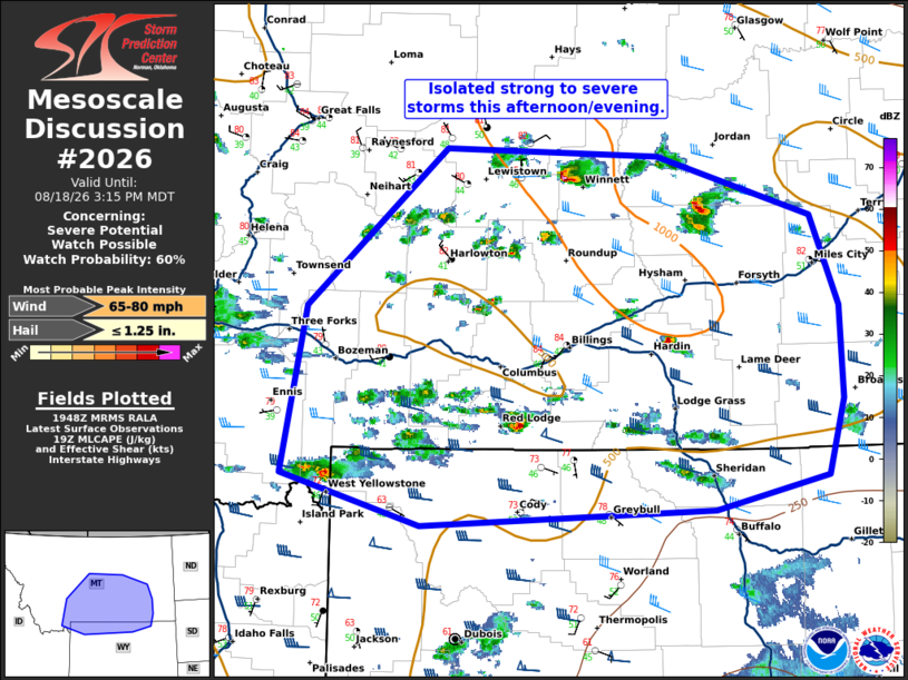
   Areas affected...southern Montana and far northern Wyoming.

   Concerning...Severe potential...Watch possible

   Valid 181951Z - 182115Z

   Probability of Watch Issuance...60 percent

   SUMMARY...Isolated strong to severe storms are possible this
   afternoon/evening across southern Montana and far northern Wyoming.

   DISCUSSION...Storm coverage has increased across central and
   southern Montana over the last hour ahead of a mid-level shortwave
   trough. Relatively weak instability is in place amid mostly 40sF
   dewpoints. However, strong heating (mid to upper 80s) has yielded
   steep lapse rates across the region. Moderate mid-upper level flow
   (40-55 kts) will support storm organization including the potential
   for supercells. The weak instability should limit the hail threat
   somewhat, but the steep lapse rates and dry sub-cloud layer should
   support some severe wind threat, including the potential for a few
   75+ mph wind gusts.

   Expect storms to remain mostly cellular which may limit a more
   widespread severe wind threat. However, the stronger cores which
   develop may be efficient wind producers. The downstream threat
   across northern Wyoming remains uncertain due to extensive cloud
   cover and limited heating.

   ..Bentley/Guyer.. 08/18/2026

   ...Please see www.spc.noaa.gov for graphic product...

   ATTN...WFO...UNR...BYZ...GGW...RIW...TFX...PIH...

   LAT...LON   47280983 47230752 47090704 46760586 46080555 45370552
               44790570 44520692 44401010 44791160 46081135 47280983

   MOST PROBABLE PEAK WIND GUST...65-80 MPH
   MOST PROBABLE PEAK HAIL SIZE...UP TO 1.25 IN
|
|
|
Top/All Mesoscale Discussions/Forecast Products/Home |
|
Source link