

| Mesoscale Discussion 2025 | |
| < Previous MD Next MD > | |
|
|
   Mesoscale Discussion 2025
   NWS Storm Prediction Center Norman OK
   0247 PM CDT Tue Aug 18 2026

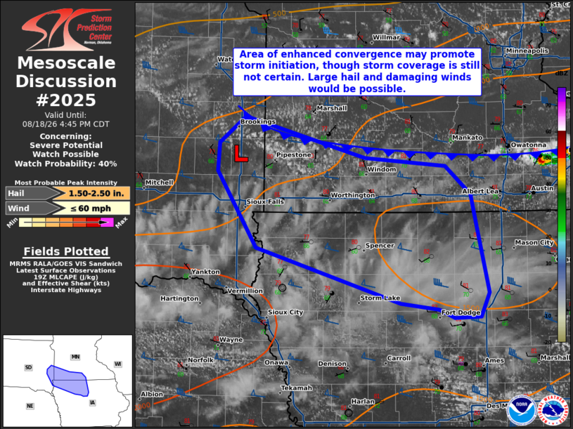
   Areas affected...Far southeast South Dakota into southern Minnesota
   and northern Iowa

   Concerning...Severe potential...Watch possible

   Valid 181947Z - 182145Z

   Probability of Watch Issuance...40 percent

   SUMMARY...While uncertainty in storm coverage remains, large hail
   and damaging winds would be possible with storms that may develop
   along the cold front. Convective trends will be monitored through
   the afternoon for a possible watch.

   DISCUSSION...Cumulus have been deepening near a weak mesoscale low
   in southeast South Dakota. Additional cumulus towers have been
   observed along the cold front farther east, though convergence is
   much weaker and agitated cumulus have not been long lived. With
   around 50 kt of shear and destabilization occurring south of the
   front, large hail (potentially near 2 in.) and damaging winds would
   be possible. The main question will be how many storms will be able
   to form this afternoon. The weak surface convergence across much of
   the front and upper-level clouds moving in from the west limit
   confidence in this regard. Some CAM guidance has suggested storm
   development along the front may be delayed until late
   afternoon/early evening when a stronger southerly surge of the front
   is expected. Convective trends will need to be monitored for a
   possible watch.

   ..Wendt/Guyer.. 08/18/2026

   ...Please see www.spc.noaa.gov for graphic product...

   ATTN...WFO...MPX...DMX...FSD...

   LAT...LON   44159704 44409669 44019512 43939408 43669375 43429368
               42739352 42499362 42499396 42569417 42629467 43159654
               43899706 44159704

   MOST PROBABLE PEAK WIND GUST...UP TO 60 MPH
   MOST PROBABLE PEAK HAIL SIZE...1.50-2.50 IN
|
|
|
Top/All Mesoscale Discussions/Forecast Products/Home |
|
Source link