

| Mesoscale Discussion 2023 | |
| < Previous MD | |
|
|
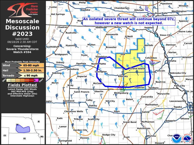
Mesoscale Discussion 2023 NWS Storm Prediction Center Norman OK 0124 AM CDT Tue Aug 18 2026 Areas affected...portions of central and eastern Nebraska Concerning...Severe Thunderstorm Watch 594... Valid 180624Z - 180730Z The severe weather threat for Severe Thunderstorm Watch 594 continues. SUMMARY...An isolated severe wind and hail threat is likely to continue after the scheduled 07z/2 am CDT expiration of Severe Thunderstorm Watch 594, and a local extension in time and area may be needed for portions of the discussion area. DISCUSSION...A compact cluster of strong/severe storms continues over portions central NE at 0615z, with a recent report of a measured 79 mph gust at Grand Island, NE. This cluster continues to move southeast at 50 mph, and a severe wind risk will likely continue through 07-08z given a favorable near-term downstream environment. Thus a local extension in time and/or area may be needed to cover this threat. As low-level warm advection strengthens farther west, new thunderstorm development is anticipated over central/south-central NE within a steep mid-level lapse rate environment and modestly strong mid-level flow. A localized wind and hail threat is expected with this new development into the early morning hours, however the overall coverage is expected to remain such that a new watch is not currently expected. ..Bunting/Mosier.. 08/18/2026 ...Please see www.spc.noaa.gov for graphic product... ATTN...WFO...OAX...GID...LBF... LAT...LON 40969856 41239741 41169713 40569701 40239714 40109838 40129925 40149984 40380015 40600037 40840037 41470021 41559957 40969856 MOST PROBABLE PEAK TORNADO INTENSITY...UP TO 90 MPH MOST PROBABLE PEAK WIND GUST...65-80 MPH MOST PROBABLE PEAK HAIL SIZE...1.50-2.50 IN |
|
|
Top/All Mesoscale Discussions/Forecast Products/Home |
|
Source link