

| Mesoscale Discussion 2017 | |
| < Previous MD | |
|
|
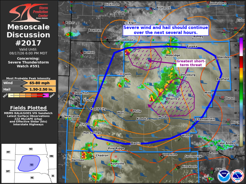
Mesoscale Discussion 2017 NWS Storm Prediction Center Norman OK 0554 PM CDT Mon Aug 17 2026 Areas affected...portions of western and central South Dakota Concerning...Severe Thunderstorm Watch 591... Valid 172254Z - 180000Z The severe weather threat for Severe Thunderstorm Watch 591 continues. SUMMARY...The risk for severe wind and hail will continue across western and central SD over the next several hours. An instance of 2+ inch diameter hail or a 75+ mph gust is possible. DISCUSSION...Multicells and supercells continue to progress across western and central SD. Several severe gusts have been reported, with MRMS MESH data suggesting hail over 1.5 inches diameter has fallen from some of the stronger storms. A buoyant and sheared airmass precedes the ongoing storms, with 1500+ J/kg MLCAPE coinciding with 45-60 kts of effective bulk shear over much of central SD. The current thinking is that supercell structures will be maintained for at least a few more hours, accompanied by a severe wind/hail threat. The best chance for severe, including significant severe wind/hail, will be with the more sustained, mature supercells currently over central and northwestern SD. ..Squitieri.. 08/17/2026 ...Please see www.spc.noaa.gov for graphic product... ATTN...WFO...FSD...ABR...UNR... LAT...LON 43730335 45640236 45790185 45820036 45779904 45559851 45079829 44379868 43949904 43549961 43360025 43220108 43210191 43350294 43730335 MOST PROBABLE PEAK WIND GUST...65-80 MPH MOST PROBABLE PEAK HAIL SIZE...1.50-2.50 IN |
|
|
Top/All Mesoscale Discussions/Forecast Products/Home |
|
Source link