

| Mesoscale Discussion 2013 | |
| < Previous MD Next MD > | |

|
|
   Mesoscale Discussion 2013
   NWS Storm Prediction Center Norman OK
   0400 PM CDT Mon Aug 17 2026

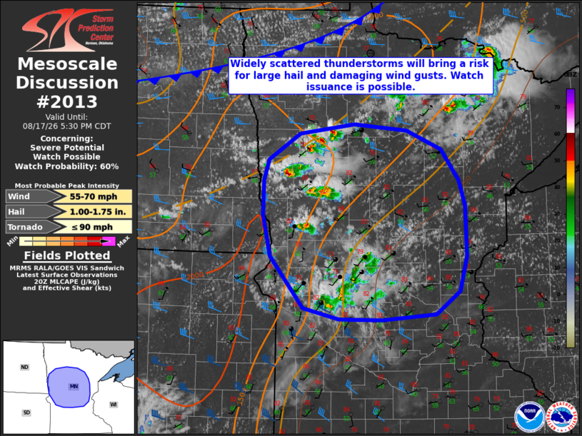
   Areas affected...portions of western and central Minnesota

   Concerning...Severe potential...Watch possible

   Valid 172100Z - 172230Z

   Probability of Watch Issuance...60 percent

   SUMMARY...Widely scattered to scattered thunderstorms will pose a
   risk for at least isolated large hail and damaging wind gusts
   through this evening across portions of western and central
   Minnesota. Watch issuance is possible.

   DISCUSSION...Isolated thunderstorm development has occurred along a
   prefrontal trough/confluence zone in west-central Minnesota.
   Enhanced low-level moisture (dewpoints in the low-to-mid 60s F)
   along/ahead of this boundary is contributing to modest buoyancy of
   500-1000 J/kg MLCAPE, with additional destabilization expected
   through late afternoon. Strong mid- and upper-level westerly flow
   (30-35 kts sampled at 2-4 km AGL by the MVX VWP) and strengthening
   effective shear will promote updraft organization with supercells
   possible initially. While mid-level lapse rates remain modest
   (around 6 K/km), at least some potential for large hail is likely to
   exist with any supercells that develop/persist given elongated
   hodographs and appreciable buoyancy within the hail growth zone.
   Latest guidance continues to suggest that relatively rapid upscale
   growth into a forward-propagating linear/bowing cluster will then
   occur, which would favor a greater risk for damaging wind gusts. A
   Severe Thunderstorm Watch may be needed to cover this risk.

   ..Chalmers/Guyer.. 08/17/2026

   ...Please see www.spc.noaa.gov for graphic product...

   ATTN...WFO...DLH...MPX...FGF...ABR...

   LAT...LON   46429672 46859671 47129661 47459604 47579506 47499410
               47249346 46859314 46539303 45899301 45469314 45179358
               45109454 45119532 45259598 45899658 46429672

   MOST PROBABLE PEAK TORNADO INTENSITY...UP TO 90 MPH
   MOST PROBABLE PEAK WIND GUST...55-70 MPH
   MOST PROBABLE PEAK HAIL SIZE...1.00-1.75 IN
|
|
|
Top/All Mesoscale Discussions/Forecast Products/Home |
|
Source link