

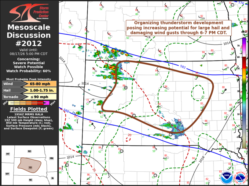
| Mesoscale Discussion 2012 | |
| < Previous MD | |

|
|
   Mesoscale Discussion 2012
   NWS Storm Prediction Center Norman OK
   0258 PM CDT Mon Aug 17 2026

   Areas affected...much of central South Dakota

   Concerning...Severe potential...Watch possible

   Valid 171958Z - 172200Z

   Probability of Watch Issuance...60 percent

   SUMMARY...Organizing thunderstorm development may pose increasing
   potential to produce large hail and damaging wind gusts into the 6-7
   PM CDT time frame.  A severe weather watch probably will be needed
   at some point, though how soon remains somewhat unclear.

   DISCUSSION...Thunderstorm development has been increasing across the
   high plains near and to the north of the Black Hills vicinity into
   southwestern North Dakota.  Based on the latest Rapid Refresh
   output, it appears that this is being aided by forcing for ascent
   associated with weak lower/mid-tropospheric warm advection, to the
   south of larger-scale  mid-level troughing digging southeast of the
   Canadian Prairies through the international border area.  With
   further progression of this trough, west-northwesterly flow in the
   700-500 mb layer is forecast to strengthen in a belt of across
   southeastern Montana through north central South Dakota into early
   evening.

   Within this regime, ongoing storms are likely to continue a general
   southeastward propagation, with potential to undergo substantive
   further intensification and upscale growth.  An increasingly moist
   low-level environment into and across the middle Missouri Valley
   around Pierre may support updraft inflow increasingly characterized
   by CAPE in excess of 1500-2000+ J/kg, in the presence of
   strengthening deep-layer shear.  This probably will contribute to
   evolving supercell structures with potential to produce large hail
   and damaging wind gusts, which could consolidate into an upscale
   growing cluster by early evening.

   ..Kerr/Guyer.. 08/17/2026

   ...Please see www.spc.noaa.gov for graphic product...

   ATTN...WFO...FSD...ABR...UNR...

   LAT...LON   45920223 45579932 45059774 43479935 44120213 44270314
               45100252 45920223

   MOST PROBABLE PEAK TORNADO INTENSITY...UP TO 90 MPH
   MOST PROBABLE PEAK WIND GUST...65-80 MPH
   MOST PROBABLE PEAK HAIL SIZE...1.00-1.75 IN
|
|
|
Top/All Mesoscale Discussions/Forecast Products/Home |
|
Source link