

| Mesoscale Discussion 2011 | |
| < Previous MD | |

|
|
   Mesoscale Discussion 2011
   NWS Storm Prediction Center Norman OK
   1249 PM CDT Mon Aug 17 2026

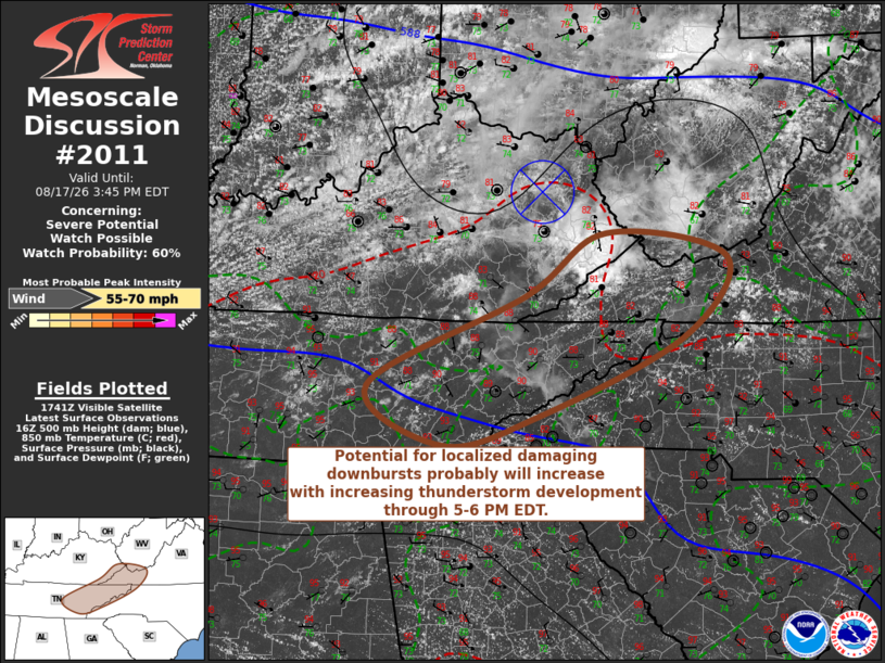
   Areas affected...parts of southeastern Kentucky...southwestern
   Virginia...eastern Tennessee and adjacent portions of western North
   Carolina

   Concerning...Severe potential...Watch possible

   Valid 171749Z - 171945Z

   Probability of Watch Issuance...60 percent

   SUMMARY...Potential for localized damaging downbursts will gradually
   increase with increasing thunderstorm development through 5-6 PM
   EDT.  Trends are being monitored for the possibility of a severe
   weather watch.

   DISCUSSION...Thunderstorms have recently begun to develop and
   intensify in a small cluster south of a remnant MCV now migrating
   east-southeastward across eastern Kentucky.  This appears embedded
   within modest west-southwesterly deep-layer ambient mean flow on the
   order of 20-25 kt, but Rapid-Refresh output and VWP data suggest a
   belt of flow on the order of 30-40 in the 700-500 mb layer to the
   south of the MCV.

   As a seasonably moist boundary layer continues to approach 90F ahead
   of ongoing storms, and ahead of a weak, convectively generated or
   augmented front trailing to the southwest of the MCV, boundary-layer
   destabilization will probably support further intensification and
   upscale growth of ongoing storms, as well as increasing new storm
   development into the western slopes of the Appalachians.  Aided by
   thermodynamic profiles with modestly steep lower to mid-tropospheric
   lapse rates of temperature and potential wet-bulb temperature,
   potential for localized damaging downbursts may increase through
   20-21Z.

   ..Kerr/Guyer.. 08/17/2026

   ...Please see www.spc.noaa.gov for graphic product...

   ATTN...WFO...RNK...RLX...GSP...MRX...JKL...OHX...

   LAT...LON   37588245 37318078 36428137 35538340 35208470 35868574
               36878356 37588245

   MOST PROBABLE PEAK WIND GUST...55-70 MPH
|
|
|
Top/All Mesoscale Discussions/Forecast Products/Home |
|
Source link