

| Mesoscale Discussion 2009 | |
| < Previous MD | |
|
|
   Mesoscale Discussion 2009
   NWS Storm Prediction Center Norman OK
   0213 AM CDT Mon Aug 17 2026

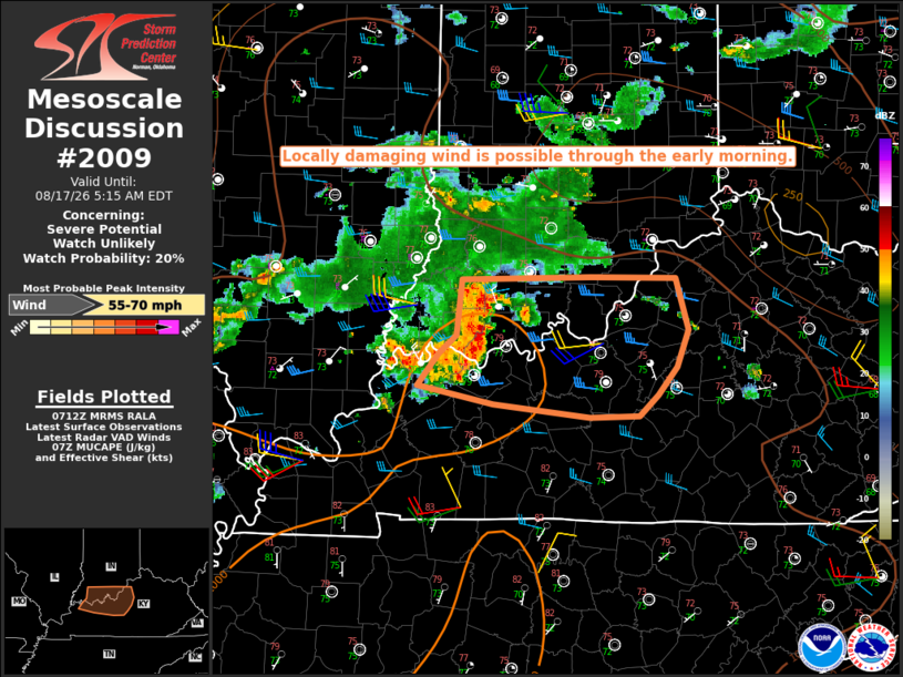
   Areas affected...Southern IN into parts of northern KY

   Concerning...Severe potential...Watch unlikely

   Valid 170713Z - 170915Z

   Probability of Watch Issuance...20 percent

   SUMMARY...Locally damaging wind is possible through the early
   morning.

   DISCUSSION...A small MCS has recently shown some signs of increased
   intensity and organization as it approaches northwest KY early this
   morning. While lapse rates are generally weak, rich moisture (with
   PW near/above 2 inches) is helping to maintain moderate buoyancy in
   advance of this system, with sufficient deep-layer flow for some
   storm organization.  The generally unidirectional westerly flow
   above the surface (with some increase in 1-3 km AGL flow noted in
   regional VWPs) will continue to be favorable for an eastward-moving
   MCS through the early morning hours.

   The poor low-level lapse rates may continue to mitigate the
   severe-wind threat to some extent, though a severe gust was recently
   observed within a separate area of convection across southern IN. At
   least isolated wind-damage potential is expected to spread eastward
   through the early morning, especially near/south of an outflow
   boundary near the IN/KY border, where warmer surface temperatures
   remain in place. Eventually, decreasing buoyancy and increasing
   inhibition with time and eastward extent is expected to lead to a
   weakening trend

   ..Dean/Mosier.. 08/17/2026

   ...Please see www.spc.noaa.gov for graphic product...

   ATTN...WFO...LMK...PAH...

   LAT...LON   38448728 38468605 38458525 38078512 37788523 37588542
               37428559 37408606 37518698 37648770 37888750 38028733
               38448728

   MOST PROBABLE PEAK WIND GUST...55-70 MPH
|
|
|
Top/All Mesoscale Discussions/Forecast Products/Home |
|
Source link