

| Mesoscale Discussion 2004 | |
| < Previous MD | |
|
|
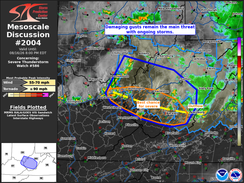
Mesoscale Discussion 2004 NWS Storm Prediction Center Norman OK 0531 PM CDT Sun Aug 16 2026 Areas affected...portions of central and southern West Virginia Concerning...Severe Thunderstorm Watch 586... Valid 162231Z - 170000Z The severe weather threat for Severe Thunderstorm Watch 586 continues. SUMMARY...A few damaging gusts are possible over the next few hours. The best chance for severe storms will be with storms moving along the leading edge of outflow from earlier storms. DISCUSSION...Multicell storms continue to propagate southeastward amid 2000-3000 J/kg MLCAPE, supported mainly by 7-7.5 C/km boundary-layer lapse rates and 70s F surface dewpoints. These favorable thermodynamic conditions are prevalent along and south of an outflow boundary left behind by earlier thunderstorms. Storms traversing this boundary will have the best chance for producing a damaging or severe gust, and a brief tornado cannot be completely ruled out. ..Squitieri.. 08/16/2026 ...Please see www.spc.noaa.gov for graphic product... ATTN...WFO...RNK...RLX...JKL...ILN... LAT...LON 39328255 38948090 38438016 37978020 37558051 37488105 37678195 37898253 38098298 38358317 39328255 MOST PROBABLE PEAK TORNADO INTENSITY...UP TO 90 MPH MOST PROBABLE PEAK WIND GUST...55-70 MPH |
|
|
Top/All Mesoscale Discussions/Forecast Products/Home |
|
Source link