

| Mesoscale Discussion 2002 | |
| < Previous MD Next MD > | |

|
|
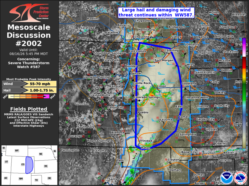
Mesoscale Discussion 2002 NWS Storm Prediction Center Norman OK 0450 PM CDT Sun Aug 16 2026 Areas affected...eastern Colorado Concerning...Severe Thunderstorm Watch 587... Valid 162150Z - 162345Z The severe weather threat for Severe Thunderstorm Watch 587 continues. SUMMARY...Large hail and damaging wind threat continues within WW587. DISCUSSION...A cluster of storms south of the Denver Metro has produced severe gusts up to 62 mph. Mode remains fairly mixed, with multi-cell clusters and supercells ongoing across portions of eastern Colorado. The environment remains moderately unstable with around 30-35 kts of deep layer shear. Severe potential will likely increase with movement eastward into more available 60 F degree dew points. Supercells with large hail potential will continue over the next couple of hours before eventual transition to one or more linear clusters. An increase in the damaging wind threat is expected eastward into the lower Plains by the evening. ..Thornton.. 08/16/2026 ...Please see www.spc.noaa.gov for graphic product... ATTN...WFO...GLD...PUB...BOU...ABQ... LAT...LON 38760467 39300465 39690466 40410468 41000451 40770301 40050259 39380246 38490246 37620276 37130347 36940402 36910437 37050467 38760467 MOST PROBABLE PEAK WIND GUST...55-70 MPH MOST PROBABLE PEAK HAIL SIZE...1.00-1.75 IN |
|
|
Top/All Mesoscale Discussions/Forecast Products/Home |
|
Source link