

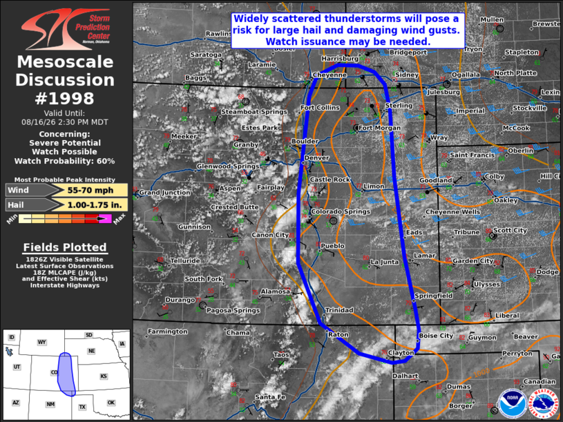
| Mesoscale Discussion 1998 | |
| < Previous MD | |

|
|
   Mesoscale Discussion 1998
   NWS Storm Prediction Center Norman OK
   0133 PM CDT Sun Aug 16 2026

   Areas affected...portions of the central High Plains

   Concerning...Severe potential...Watch possible

   Valid 161833Z - 162030Z

   Probability of Watch Issuance...60 percent

   SUMMARY...Widely scattered thunderstorms will develop along the
   Colorado Front Range and Raton Mesa vicinity this afternoon,
   bringing a risk for large hail and damaging wind gusts to portions
   of the central High Plains.

   DISCUSSION...Aided by strong diurnal heating and easterly, upslope
   flow with dewpoints near 60 F, widely scattered thunderstorm
   formation is expected this afternoon along the CO Front Range and
   Raton Mesa vicinity of the central High Plains, with some lightning
   activity already noted within deeper updrafts as of 1830 UTC. Around
   1500 J/kg MLCAPE (increasing to 2000 J/kg locally by peak heating
   this afternoon) and 25-35+ kts of effective shear amid modestly
   strong westerly flow aloft will aid in the organization of updrafts
   and should support at least a couple of supercells. These storms
   will pose a risk for primarily large hail owing to the presence of
   steep mid-level lapse rates exceeding 7-7.5 C/km, with a few
   damaging/severe wind gusts also possible. A more
   outflow-dominant/cluster storm mode, and proportionally greater
   damaging/severe wind gust risk, should be increasingly favored with
   southward extent as objective analysis indicates effective shear
   decreases to 20-25 kts across southeastern Colorado and areas
   farther south. A Severe Thunderstorm Watch may be needed for at
   least a portion of the discussion area to cover these threats.

   ..Chalmers/Guyer.. 08/16/2026

   ...Please see www.spc.noaa.gov for graphic product...

   ATTN...WFO...GLD...AMA...PUB...BOU...CYS...ABQ...

   LAT...LON   36360306 36520375 37020458 38040506 39210506 40850486
               41200469 41390422 41370377 41270341 41050317 40610307
               39480299 38140279 37250256 36900249 36600252 36390280
               36360306

   MOST PROBABLE PEAK WIND GUST...55-70 MPH
   MOST PROBABLE PEAK HAIL SIZE...1.00-1.75 IN
|
|
|
Top/All Mesoscale Discussions/Forecast Products/Home |
|
Source link