

| Mesoscale Discussion 1993 | |
| < Previous MD | |

|
|
   Mesoscale Discussion 1993
   NWS Storm Prediction Center Norman OK
   0823 PM CDT Sat Aug 15 2026

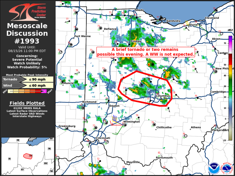
   Areas affected...parts of central OH

   Concerning...Severe potential...Watch unlikely

   Valid 160123Z - 160300Z

   Probability of Watch Issuance...5 percent

   SUMMARY...A low-topped miniature supercell over central OH may
   continue for another hour or two this evening. A brief tornado
   remains possible. A Watch is currently not expected.

   DISCUSSION...As of 0120 UTC, the Dayton, OH TDWR and KILN NEXRAD
   showed a miniature supercell over Champaign County, OH. This storm
   is ongoing within a broader cluster of low-topped convection near a
   remnant MCV across central OH. The environment is not particularly
   unstable (MLCAPE 500-1000 J/kg), but is very moist, with dewpoints
   in the mid 70s F. This is supporting low cloud bases amid enlarged
   low-level hodographs ahead of the MCV. SPC mesoanalysis shows ESRH
   of 100-200 m2/s2 across central OH which could support occasional
   low-level rotation despite much weaker deep-layer shear.

   This storm has displayed intermittent low-level mesocyclones and
   potentially produced a brief tornado earlier this evening from
   public reports. The modestly supportive environment and cellular
   storm mode suggest a brief tornado or two will remain possible as
   the storm moves eastward over the next couple of hours. However, the
   lack of stronger deep-layer shear and weak buoyancy favor only
   intermittent intensification. Increasing inhibition is also expected
   to slowly diminish the threat later this evening. Given the brief
   and localized nature of the threat, a Watch is not anticipated.

   ..Lyons/Gleason.. 08/16/2026

   ...Please see www.spc.noaa.gov for graphic product...

   ATTN...WFO...CLE...ILN...

   LAT...LON   39908358 39948367 40038385 40138395 40328388 40498347
               40318269 40168257 39938256 39808272 39808287 39908358

   MOST PROBABLE PEAK TORNADO INTENSITY...UP TO 90 MPH
   MOST PROBABLE PEAK WIND GUST...UP TO 60 MPH
|
|
|
Top/All Mesoscale Discussions/Forecast Products/Home |
|
Source link