

| Mesoscale Discussion 1990 | |
| < Previous MD Next MD > | |

|
|
   Mesoscale Discussion 1990
   NWS Storm Prediction Center Norman OK
   0356 PM CDT Sat Aug 15 2026

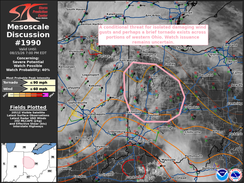
   Areas affected...portions of far eastern Indiana into far western
   Ohio

   Concerning...Severe potential...Watch possible

   Valid 152056Z - 152300Z

   Probability of Watch Issuance...40 percent

   SUMMARY...A conditional risk for isolated damaging wind gusts and
   perhaps a brief tornado exists across portions of far eastern
   Indiana into western Ohio. The need for a watch remains unclear.

   DISCUSSION...Filtered diurnal heating downstream of an MCV readily
   apparent in observation data has allowed surface temperatures to
   warm into the low 80s F across portions of eastern IN/western OH,
   with latest objective analysis depicting around 1000 J/kg MLCAPE
   across this area. While some inhibition remains, deepening cumulus
   are noted in some areas of clearer skies. Recent CAM guidance
   continues to suggest that isolated thunderstorm development may
   occur in the next 1-3 hours across this region as ascent downstream
   of the approaching MCV continues to overspread the region. Should
   this occur, enhanced mid-level flow (sampled by the IND VWP) would
   be sufficient to support at least transient supercell structures
   should storms develop. In this scenario, poor low- and mid-level
   lapse rates would likely temper overall convective intensity, but
   modestly enhanced low-level shear and backing low-level flow
   (sampled by the ILN VWP) may support a conditional risk for isolated
   damaging wind gusts and perhaps a brief tornado. This scenario
   remains uncertain, but trends will continue to be monitored for
   potential watch issuance.

   ..Chalmers/Guyer.. 08/15/2026

   ...Please see www.spc.noaa.gov for graphic product...

   ATTN...WFO...CLE...ILN...IWX...IND...

   LAT...LON   41148467 41088390 40678314 40258296 39838314 39648352
               39648428 39888474 40288492 40888495 41148467

   MOST PROBABLE PEAK TORNADO INTENSITY...UP TO 90 MPH
   MOST PROBABLE PEAK WIND GUST...UP TO 60 MPH
|
|
|
Top/All Mesoscale Discussions/Forecast Products/Home |
|
Source link