

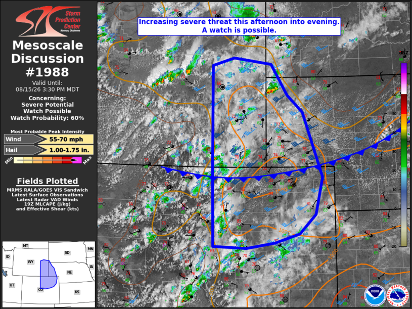
| Mesoscale Discussion 1988 | |
| < Previous MD | |

|
|
   Mesoscale Discussion 1988
   NWS Storm Prediction Center Norman OK
   0228 PM CDT Sat Aug 15 2026

   Areas affected...eastern Wyoming and northeast Colorado into far
   southwest South Dakota and the Nebraska Panhandle

   Concerning...Severe potential...Watch possible

   Valid 151928Z - 152130Z

   Probability of Watch Issuance...60 percent

   SUMMARY...The potential for severe storms capable of large hail and
   severe wind gusts is expected to increase this afternoon into
   evening. A severe thunderstorm watch is possible.

   DISCUSSION...Visible satellite imagery and lightning data indicate
   thunderstorms developing over the central Rockies, including the CO
   Front Range, with additional storms noted over central into
   northeast WY, and the far northwest NE Panhandle. More widespread
   cloud cover has slowed daytime heating across portions of the
   adjacent High Plains, where latest objective analysis indicates
   lingering convective inhibition. However, continued daytime heating
   should allow the cap to weaken, thereby allowing storms to advance
   into the High Plains, amidst a steep lapse rate environment
   featuring MLCAPE of 1000-1500 J/kg. When coupled with 30-40 kt of
   deep-layer shear, the setup will support multicell and some
   supercell storm modes capable of mainly large hail initially. Latest
   CAM guidance continues to suggest that storms will grow upscale into
   clusters this evening with an associated increase in severe wind
   gust potential.

   ..Mead/Guyer.. 08/15/2026

   ...Please see www.spc.noaa.gov for graphic product...

   ATTN...WFO...LBF...UNR...GLD...BOU...CYS...

   LAT...LON   39230558 41060562 43250564 43430501 43280389 42600341
               42220297 40760240 39940260 39500307 39300380 39180462
               39230558

   MOST PROBABLE PEAK WIND GUST...55-70 MPH
   MOST PROBABLE PEAK HAIL SIZE...1.00-1.75 IN
|
|
|
Top/All Mesoscale Discussions/Forecast Products/Home |
|
Source link