

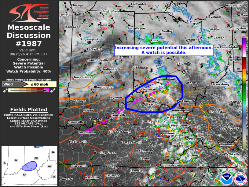
| Mesoscale Discussion 1987 | |
| < Previous MD | |

|
|
   Mesoscale Discussion 1987
   NWS Storm Prediction Center Norman OK
   0108 PM CDT Sat Aug 15 2026

   Areas affected...southwest Ohio into northeast Kentucky

   Concerning...Severe potential...Watch possible

   Valid 151808Z - 152015Z

   Probability of Watch Issuance...40 percent

   SUMMARY...Isolated severe storm potential appears to be increasing
   across the area. Convective trends are being monitored for a
   possible watch.

   DISCUSSION...Renewed thunderstorm development is underway along the
   southern flank of a recently decayed nocturnal MCS from south of
   Wilmington to the Cincinnati vicinity. Stronger heating along the
   southern periphery of the residual cloud canopy has allowed
   temperatures to warm into the mid 80s to lower 90s, which, coupled
   with dewpoints in the mid 70s, is yielding MLCAPE of 2000-2500 J/kg.
   Stronger forcing for ascent and vertical shear remain displaced to
   the northwest of the area, in closer proximity to an MCV over
   northwest IN, leading to uncertainty in the extent of the severe
   storm threat in the near term. However, the character of the
   thermodynamic environment suggests some potential for locally
   damaging wind gusts with the current storms this afternoon over the
   next 1-2 hours.

   A comparatively greater severe storm risk may materialize later this
   afternoon into evening with the arrival of the stronger forcing for
   ascent and vertical shear. Between now and then, convective trends
   are being monitored for signs of storm organization, which would
   warrant consideration of a watch issuance.

   ..Mead/Guyer.. 08/15/2026

   ...Please see www.spc.noaa.gov for graphic product...

   ATTN...WFO...RLX...JKL...ILN...LMK...

   LAT...LON   38898514 39228461 39548392 39648354 39628300 39368276
               38938272 38588311 38438360 38428443 38558511 38898514

   MOST PROBABLE PEAK WIND GUST...UP TO 60 MPH
|
|
|
Top/All Mesoscale Discussions/Forecast Products/Home |
|
Source link