

| Mesoscale Discussion 1977 | |
| < Previous MD | |

|
|
   Mesoscale Discussion 1977
   NWS Storm Prediction Center Norman OK
   0121 PM CDT Fri Aug 14 2026

   Areas affected...portions of the central Appalachians into the NC/VA
   Piedmont

   Concerning...Severe potential...Watch unlikely

   Valid 141821Z - 142015Z

   Probability of Watch Issuance...20 percent

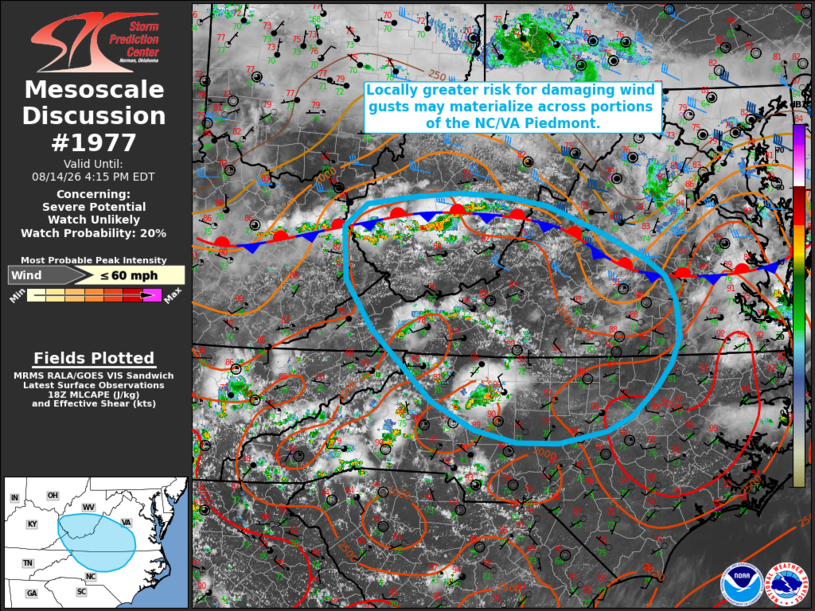
   SUMMARY...A locally greater risk for damaging wind gusts may develop
   across across portions of the NC/VA Piedmont downstream of
   developing thunderstorms.

   DISCUSSION...Latest surface analysis depicts a quasi-stationary/weak
   cold frontal boundary extending roughly west-to-east from southern
   DelMarVa into central Virginia and the central Appalachians. South
   of this boundary, continued insolation and dewpoints in the low 70s
   F should support 1500-2500+ J/kg MLCAPE by peak heating this
   afternoon, sufficient for a few stronger updrafts. Effective shear
   remains generally weak roughly south of the NC/VA border (less than
   20 kts), which will favor an outflow-dominant/pulse-severe type
   storm mode. Steepening low-level lapse rates and high PW (2+ inches
   per the 12 UTC GSO observed sounding) will support an isolated risk
   for wet microbursts and damaging wind gusts. Farther north, latest
   objective analysis suggests that effective shear is locally enhanced
   along the aforementioned surface boundary (20-30+ kts) across
   central/southern Virginia. This could allow for a locally greater
   risk for damaging wind gusts to materialize should a loosely
   organized cluster evolve east-southeastward out of West Virginia
   (where a recent report of thunderstorm wind damage is noted).
   Regardless, the overall severe risk is expected to remain relatively
   isolated and limited in magnitude. Thus, watch issuance appears
   unlikely at this time.

   ..Chalmers/Guyer.. 08/14/2026

   ...Please see www.spc.noaa.gov for graphic product...

   ATTN...WFO...AKQ...LWX...RAH...RNK...RLX...GSP...MRX...JKL...

   LAT...LON   38468151 38508091 38468024 38347955 38047878 37717810
               37497779 37217765 36767760 36447773 36167794 35837832
               35647870 35517940 35518003 35678064 36008128 36868218
               37458257 38098261 38358228 38468151

   MOST PROBABLE PEAK WIND GUST...UP TO 60 MPH
|
|
|
Top/All Mesoscale Discussions/Forecast Products/Home |
|
Source link