

| Mesoscale Discussion 1970 | |
| < Previous MD | |

|
|
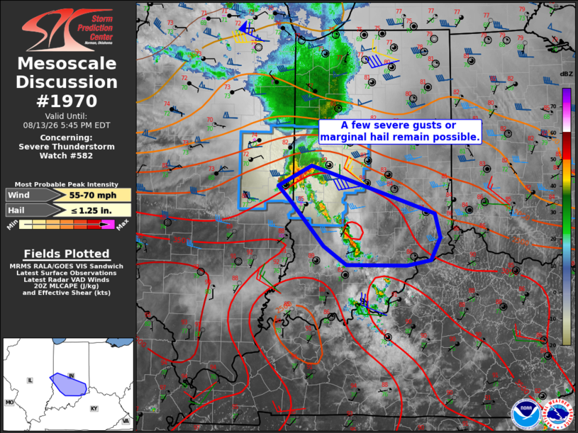
Mesoscale Discussion 1970 NWS Storm Prediction Center Norman OK 0322 PM CDT Thu Aug 13 2026 Areas affected...central to southern Indiana to the Ohio River Concerning...Severe Thunderstorm Watch 582... Valid 132022Z - 132145Z The severe weather threat for Severe Thunderstorm Watch 582 continues. SUMMARY...A threat of severe wind gusts and marginal hail will persist into central to southern Indiana. DISCUSSION...A cluster of storms on the southern periphery of the dying MCS has remained relatively strong/persistent today across central IL, and is now moving into IN. These storms continue to track along the instability gradient, with access to a very moist air mass (PWAT > 2.20") and around 3000 J/kg MLCAPE. Recent radar trends show other storms developing ahead/southeast of the main storm cluster, indicative of the uncapped air mass. Low-level wind fields are weak, but at least some rightward propagation is possible into the peak heating hours. Localized severe wind gusts will remain the main threat, though marginal hail may occur from time to time. ..Jewell.. 08/13/2026 ...Please see www.spc.noaa.gov for graphic product... ATTN...WFO...ILN...LMK...IND...ILX... LAT...LON 39958722 39318511 38998502 38698517 38628559 38638661 38898701 39488757 39698778 39958722 MOST PROBABLE PEAK WIND GUST...55-70 MPH MOST PROBABLE PEAK HAIL SIZE...UP TO 1.25 IN |
|
|
Top/All Mesoscale Discussions/Forecast Products/Home |
|
Source link