

| Mesoscale Discussion 1964 | |
| < Previous MD | |
|
|
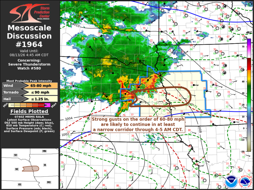
Mesoscale Discussion 1964 NWS Storm Prediction Center Norman OK 0242 AM CDT Thu Aug 13 2026 Areas affected...parts of east central Nebraska through central Iowa Concerning...Severe Thunderstorm Watch 580... Valid 130742Z - 130945Z The severe weather threat for Severe Thunderstorm Watch 580 continues. SUMMARY...Strongest gusts are likely to continue in at least a narrow swath across east central Nebraska, and the Missouri River vicinity between Omaha and Tekamah, into the I-80 corridor of western Iowa through 4-5 AM CDT. DISCUSSION...The most intense convection remains concentrated near a new MCV evolving from an initial supercell now approaching the Norfolk vicinity, with an intense westerly rear inflow jet in excess of 80 kt still being sampled, at least in mid-levels in recent radar imagery. Based on its current storm motion, it still appears on track to reach the Missouri River vicinity near/north of Omaha into the Tekamah vicinity by around 09Z. Although latest objective analysis suggests that the magnitude of potentially unstable inflow could gradually begin to weaken along or just north of the I-80 corridor into central Iowa, it still seems probable that activity could maintain severe strength into the Greater Des Moines vicinity by around 11-12Z. ..Kerr.. 08/13/2026 ...Please see www.spc.noaa.gov for graphic product... ATTN...WFO...DMX...OAX...GID... LAT...LON 41759762 41849759 41959528 41379514 41299733 41309783 41519749 41759762 MOST PROBABLE PEAK TORNADO INTENSITY...UP TO 90 MPH MOST PROBABLE PEAK WIND GUST...65-80 MPH MOST PROBABLE PEAK HAIL SIZE...UP TO 1.25 IN |
|
|
Top/All Mesoscale Discussions/Forecast Products/Home |
|
Source link