

| Mesoscale Discussion 1963 | |
| < Previous MD | |

|
|
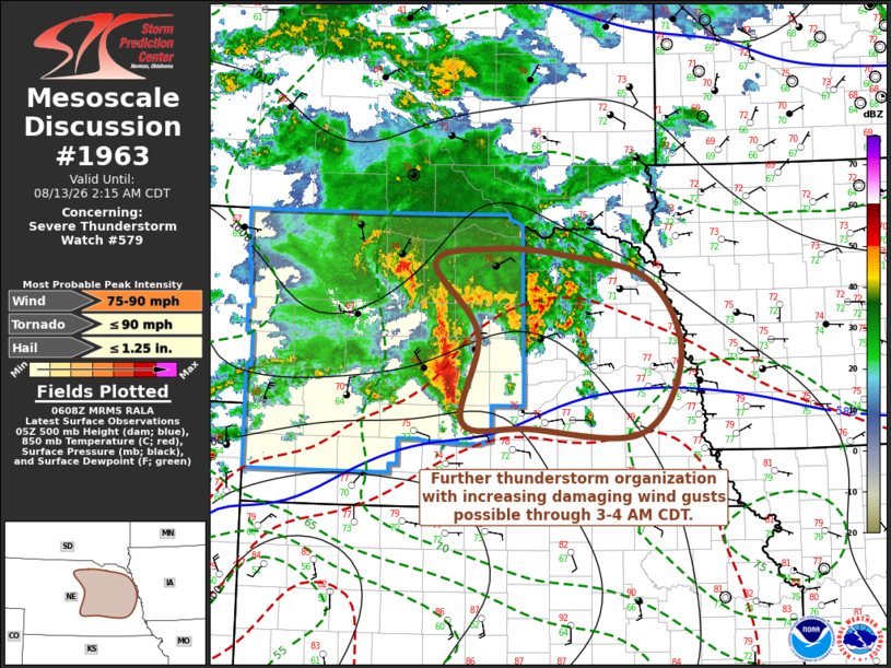
Mesoscale Discussion 1963 NWS Storm Prediction Center Norman OK 0111 AM CDT Thu Aug 13 2026 Areas affected...parts of central and eastern Nebraska Concerning...Severe Thunderstorm Watch 579... Valid 130611Z - 130715Z The severe weather threat for Severe Thunderstorm Watch 579 continues. SUMMARY...An evolving cluster of storms may undergo further organization, with increasing strong to severe surface gusts through 3-4 AM CDT. A new severe weather watch will be issued shortly. DISCUSSION...An evolving cluster of storms is still not well organized, but an MCV approaching the Ainsworth vicinity remains well defined, with at least 3-5+ mb 2 hourly surface pressure rises now evident within the cold pool spreading across/east of the Thedford and Broken Bow vicinities. Ahead of this perturbation a gust to 78 kts has recently been recorded at Broken Bow. The evolving convective system is being maintained by forcing for ascent associated with warm advection, particularly focused along a sharpening baroclinic zone centered near/just below 700 mb. In the presence of at least modest cloud-bearing layer shear, it appears that this forcing will develop eastward toward the Missouri River between Omaha and Tekamah, through 08-09Z, with a continuing updraft inflow of seasonably moist air characterized by large CAPE. This may be accompanied by further intensification and organization of the convective system with increasing potential for strong to severe surface gusts. ..Kerr.. 08/13/2026 ...Please see www.spc.noaa.gov for graphic product... ATTN...WFO...FSD...OAX...GID...LBF... LAT...LON 42499950 42649872 42599775 42329656 41559613 40769668 40819822 40879911 41789891 42499950 MOST PROBABLE PEAK TORNADO INTENSITY...UP TO 90 MPH MOST PROBABLE PEAK WIND GUST...75-90 MPH MOST PROBABLE PEAK HAIL SIZE...UP TO 1.25 IN |
|
|
Top/All Mesoscale Discussions/Forecast Products/Home |
|
Source link