

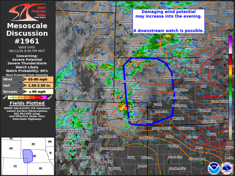
| Mesoscale Discussion 1961 | |
| < Previous MD | |

|
|
   Mesoscale Discussion 1961
   NWS Storm Prediction Center Norman OK
   0706 PM CDT Wed Aug 12 2026

   Areas affected...northeastern Colorado into western Nebraska and
   southern South Dakota

   Concerning...Severe potential...Severe Thunderstorm Watch likely

   Valid 130006Z - 130200Z

   Probability of Watch Issuance...80 percent

   SUMMARY...Damaging wind potential may increase into the evening.

   DISCUSSION...Several ongoing clusters of thunderstorms are evolving
   this evening across northern Nebraska and northeastern Colorado.
   Hi-res guidance trends have been fairly consistent run to run with
   the notion that these will eventually interact downstream across
   western/central Nebraska later this evening. The environment across
   western/central Nebraska is conditionally favorable, with strong
   MLCAPE around 2500-3000 J/kg and steep lapse rates throughout the
   profile. The air mass across northwestern Nebraska is also very well
   mixed, with temperatures in the 90s and dew points in the mid to
   upper 50s providing large dew point depressions. This will promote
   outflow dominate clusters with potential for damaging wind. Large
   hail also remains a risk in the short term.

   Should the clusters out of northern Nebraska and northeastern
   Colorado be able to establish a cold pool and spread east, they will
   have the potential for more widespread damaging wind potential (and
   perhaps significant gusts 75+ mph). Trends in the 18-22z HRRR
   guidance suggest this is a possibility. A downstream watch will be
   needed in the next couple of hours to cover this potential.

   ..Thornton/Hart.. 08/13/2026

   ...Please see www.spc.noaa.gov for graphic product...

   ATTN...WFO...LBF...GLD...BOU...CYS...

   LAT...LON   42780098 42880121 42990155 42990214 42990260 42990306
               42650349 41240332 40090308 40020293 40000201 40410060
               41410045 42360061 42780098

   MOST PROBABLE PEAK TORNADO INTENSITY...UP TO 90 MPH
   MOST PROBABLE PEAK WIND GUST...65-80 MPH
   MOST PROBABLE PEAK HAIL SIZE...1.50-2.50 IN
|
|
|
Top/All Mesoscale Discussions/Forecast Products/Home |
|
Source link