

| Mesoscale Discussion 1957 | |
| < Previous MD | |

|
|
   Mesoscale Discussion 1957
   NWS Storm Prediction Center Norman OK
   0341 PM CDT Wed Aug 12 2026

   Areas affected...portions of the Low Desert of California and
   Arizona into southern Nevada

   Concerning...Severe potential...Watch unlikely

   Valid 122041Z - 122245Z

   Probability of Watch Issuance...5 percent

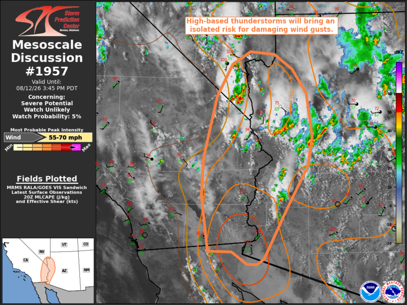
   SUMMARY...Widely scattered, high-based thunderstorms will pose an
   isolated risk for damaging wind gusts this afternoon.

   DISCUSSION...Supported by ascent ahead of an upper-level low noted
   in recent satellite imagery off of the central California coastline
   and an enhanced, mid-level moisture plume downstream of this
   feature, widely scattered thunderstorms have developed across
   portions of southern NV into the Low Desert of CA/AZ as of 2030 UTC.
   Modifying the 18 UTC VEF observed sounding for current surface
   observations depicts steep low-level lapse rates, a well-mixed
   boundary layer with LCLs around 3 km AGL, and ~1000 J/kg MLCAPE.
   While effective shear and deep-layer flow remain weak (per the ESX
   VWP), favorable thermodynamic profiles for evaporative cooling and
   downdraft accelerations will promote a risk for damaging/severe wind
   gusts across the region. Watch issuance is not anticipated, however,
   owing to the expected isolated nature of the severe risk.

   ..Chalmers/Thompson.. 08/12/2026

   ...Please see www.spc.noaa.gov for graphic product...

   ATTN...WFO...FGZ...PSR...VEF...

   LAT...LON   32541558 33601573 34301568 35451538 36051504 36291462
               36241407 35961367 35511334 34701322 34141333 33401377
               32401433 32291449 32311470 32531505 32541558

   MOST PROBABLE PEAK WIND GUST...55-70 MPH
|
|
|
Top/All Mesoscale Discussions/Forecast Products/Home |
|
Source link