

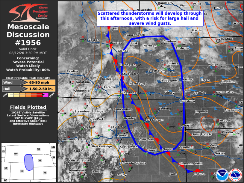
| Mesoscale Discussion 1956 | |
| < Previous MD | |

|
|
   Mesoscale Discussion 1956
   NWS Storm Prediction Center Norman OK
   0233 PM CDT Wed Aug 12 2026

   Areas affected...portions of southeastern Wyoming into northeastern
   Colorado and the Nebraska Panhandle

   Concerning...Severe potential...Watch likely

   Valid 121933Z - 122130Z

   Probability of Watch Issuance...80 percent

   SUMMARY...Scattered, initially high-based thunderstorms are expected
   to develop along and east of the Front Range over the next couple of
   hours. These storms will evolve eastward through this evening,
   bringing a threat for severe wind gusts and large hail.

   DISCUSSION...Aided by forcing for ascent ahead of a mid-level
   perturbation and along/ahead of a surface stationary/cold front,
   scattered thunderstorm development is expected along the Front Range
   from southeastern Wyoming into northern Colorado over the next 1-2
   hours. Storms will be initially high-based given hot temperatures
   and well-mixed boundary layer profiles (low-90s F temperatures amid
   dewpoints in the mid-40s) ahead of the aforementioned surface
   boundary. While effective shear around 35-40 kts will be sufficient
   for supercell structures, high cloud bases (LCLs of 2+ km AGL) and
   steep low-level lapse rates will favor efficient evaporative
   cooling, downdraft formation, and upscale growth/clustering as
   convection evolves eastward. Severe wind gusts (a few significant)
   will be the main threat with this activity, but large to very large
   hail is also expected, especially early in the convective cycle and
   with any convection that is able to maintain a discrete mode. A
   Severe Thunderstorm Watch will likely be needed for at least a
   portion of the discussion area in the next 1-2 hours to cover these
   threats.

   ..Chalmers/Thompson.. 08/12/2026

   ...Please see www.spc.noaa.gov for graphic product...

   ATTN...WFO...LBF...UNR...GLD...BOU...CYS...

   LAT...LON   39980444 40550467 41750481 42560476 42960439 43050376
               43050296 42820258 42080220 41200211 40260211 39670219
               39380251 39180335 39300381 39500414 39980444

   MOST PROBABLE PEAK WIND GUST...65-80 MPH
   MOST PROBABLE PEAK HAIL SIZE...1.50-2.50 IN
|
|
|
Top/All Mesoscale Discussions/Forecast Products/Home |
|
Source link