

| Mesoscale Discussion 1949 | |
| < Previous MD | |

|
|
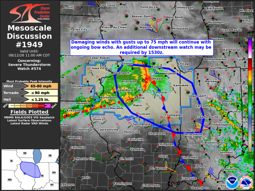
Mesoscale Discussion 1949 NWS Storm Prediction Center Norman OK 0904 AM CDT Wed Aug 12 2026 Areas affected...northern and central Illinois into western Indiana Concerning...Severe Thunderstorm Watch 574... Valid 121404Z - 121600Z The severe weather threat for Severe Thunderstorm Watch 574 continues. SUMMARY...Damaging winds with gusts up to 75 mph are expected to continue with an ongoing bow echo. The severe weather threat may develop east of the watch area by 1530Z, likely requiring a new severe thunderstorm watch. DISCUSSION...The northern extension of an MCS has sustained a bowing structure over northern IL with an eastward system motion of around 40 kt. An outflow boundary associated with an area of thunderstorms farther east extends from the vicinity of the bow echo south-southeast through eastern IL into southwest IN. The presence of that boundary may result in the MCS turning more to the southeast over the next hour to two, fueled by a strongly unstable environment, per the 12Z DVN sounding. The current DVN VWP is sampling 35-50 kt west-northwesterly winds in the 1-6 km layer, which are oriented largely perpendicular to the bow, likely maintaining a robust rear-inflow jet. As such, damaging winds are expected to continue with gusts up to 75 mph possible as the system advances toward northwest and west-central IN. Extrapolation of the current motion takes it to the eastern edge of the watch by 1530Z, likely requiring an additional watch. ..Mead.. 08/12/2026 ...Please see www.spc.noaa.gov for graphic product... ATTN...WFO...IWX...IND...LOT...ILX...DVN... LAT...LON 41909007 41758803 41268700 40498663 40088648 39578665 39578722 39588774 39848855 40268968 40819028 41499046 41909007 MOST PROBABLE PEAK TORNADO INTENSITY...UP TO 90 MPH MOST PROBABLE PEAK WIND GUST...65-80 MPH MOST PROBABLE PEAK HAIL SIZE...UP TO 1.25 IN |
|
|
Top/All Mesoscale Discussions/Forecast Products/Home |
|
Source link