

| Mesoscale Discussion 1941 | |
| < Previous MD | |

|
|
   Mesoscale Discussion 1941
   NWS Storm Prediction Center Norman OK
   0804 PM CDT Tue Aug 11 2026

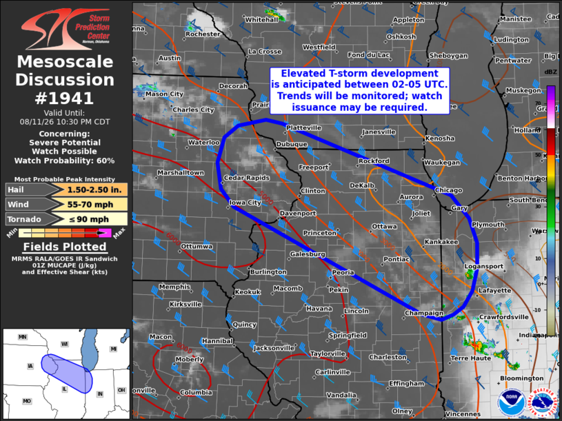
   Areas affected...Eastern Iowa into northern Illinois and far
   northwest Indiana

   Concerning...Severe potential...Watch possible

   Valid 120104Z - 120330Z

   Probability of Watch Issuance...60 percent

   SUMMARY...Strong to severe thunderstorms may materialize between
   02-05 UTC across northern Illinois into northern Indiana. These
   storms will pose a risk of large to very large hail and severe
   gusts. Trends will be monitored, and watch issuance may be needed.

   DISCUSSION...The northwestern edge of the cold pool associated with
   the earlier  passage of an MCS is becoming increasingly diffuse
   across northern IL based on recently surface observations with
   temperature warming back into the upper 70s and briefly into the 80s
   before the onset of nocturnal cooling. Aloft, westerly 700-500 mb
   flow has advected steep lapse rates eastward back into the region,
   which were well sampled by the recent DVN and ILN 00 UTC RAOBs. As a
   result, the thermodynamic environment is steadily destabilizing and
   becoming increasingly supportive of intense convection. (These
   soundings also sampled extreme buoyancy between 4000-5000 J/kg
   MLCAPE and weak inhibition around -50 J/kg.)

   Over the past few hours, a subtle disturbance has been tracked
   across IA, evident by weak mid-level ascent. This feature has been
   supporting weak attempts at convection across southern MN and
   western WI, and will likely promote additional attempts within the
   destabilizing air mass across far eastern IA into northern IL later
   this evening. Latest guidance suggests that convective initiation is
   likely between 02-05 UTC, and will likely be focused along and north
   of the residual outflow boundary. Initially discrete to
   semi-discrete cells may mature into supercells before storm
   interactions within the zone of ascent promote clustering and
   upscale growth. Large to very large hail will be possible given the
   ample buoyancy and around 40 knots of effective shear if initially
   discrete modes can be adequately sustained. Strong to severe winds
   also appear possible given the shallow nature of the residual cold
   pool across northern IL. It remains unclear exactly how long
   discrete storm modes will persist and how far downstream into IN
   convection will develop. Regardless, trends will be monitored, and
   watch issuance is probable given the favorable convective
   environment.

   ..Moore/Mosier.. 08/12/2026

   ...Please see www.spc.noaa.gov for graphic product...

   ATTN...WFO...IWX...IND...LOT...ILX...MKX...DVN...ARX...

   LAT...LON   40168790 41669142 41919167 42299174 42649163 42819136
               42919083 42859053 41848731 41518698 41158685 40798685
               40478695 40258713 40148731 40088754 40168790

   MOST PROBABLE PEAK TORNADO INTENSITY...UP TO 90 MPH
   MOST PROBABLE PEAK WIND GUST...55-70 MPH
   MOST PROBABLE PEAK HAIL SIZE...1.50-2.50 IN
|
|
|
Top/All Mesoscale Discussions/Forecast Products/Home |
|
Source link