

| Mesoscale Discussion 1933 | |
| < Previous MD | |

|
|
   Mesoscale Discussion 1933
   NWS Storm Prediction Center Norman OK
   0442 PM CDT Tue Aug 11 2026

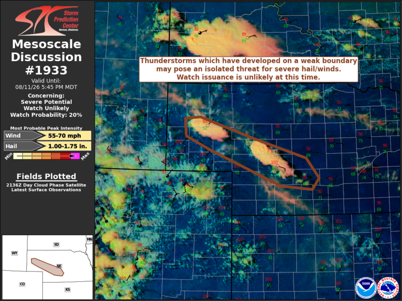
   Areas affected...Parts of the NE Panhandle into southwest NE

   Concerning...Severe potential...Watch unlikely

   Valid 112142Z - 112345Z

   Probability of Watch Issuance...20 percent

   SUMMARY...Thunderstorms which have developed on a weak surface
   boundary this afternoon may pose an isolated threat for severe
   hail/gusts. However, watch issuance is unlikely at this time.

   DISCUSSION...21Z surface observations and recent visible satellite
   imagery show a weak surface boundary draped from the NE Panhandle
   into parts of southwest/south-central NE. While large-scale ascent
   remains nebulous/weak across this region, modest low-level
   convergence along the boundary has been sufficient for widely spaced
   thunderstorm development as convective temperatures have been
   breached (surface temperatures in the mid 90s to low 100s).
   Modifying the 18Z LBF sounding for current surface observations
   suggest MLCIN has become minimal near this boundary, with ample
   MLCAPE to support robust updrafts. Furthermore, modest low-level
   winds veer to westerly and strengthen with height through mid-levels
   (reference recent KLNX VWP), which will support sufficient
   deep-layer shear for organized updrafts. Ongoing high-based
   convection may pose a threat for both isolated severe hail and gusty
   downdraft winds. Still, cooler surface temperatures to the east of
   the boundary in NE suggest the presence of stronger MLCIN with
   eastward extent, and it remains unclear whether additional
   thunderstorms will develop/move off the boundary given nebulous
   large-scale forcing. Therefore, expectations are for the overall
   severe threat to remain fairly isolated, and watch issuance appears
   unlikely at this time.

   ..Gleason/Mosier.. 08/11/2026

   ...Please see www.spc.noaa.gov for graphic product...

   ATTN...WFO...GID...LBF...CYS...

   LAT...LON   41790345 42200349 42240303 41760145 41309982 40839944
               40579965 40670059 41480272 41790345

   MOST PROBABLE PEAK WIND GUST...55-70 MPH
   MOST PROBABLE PEAK HAIL SIZE...1.00-1.75 IN
|
|
|
Top/All Mesoscale Discussions/Forecast Products/Home |
|
Source link