

| Mesoscale Discussion 1930 | |
| < Previous MD Next MD > | |

|
|
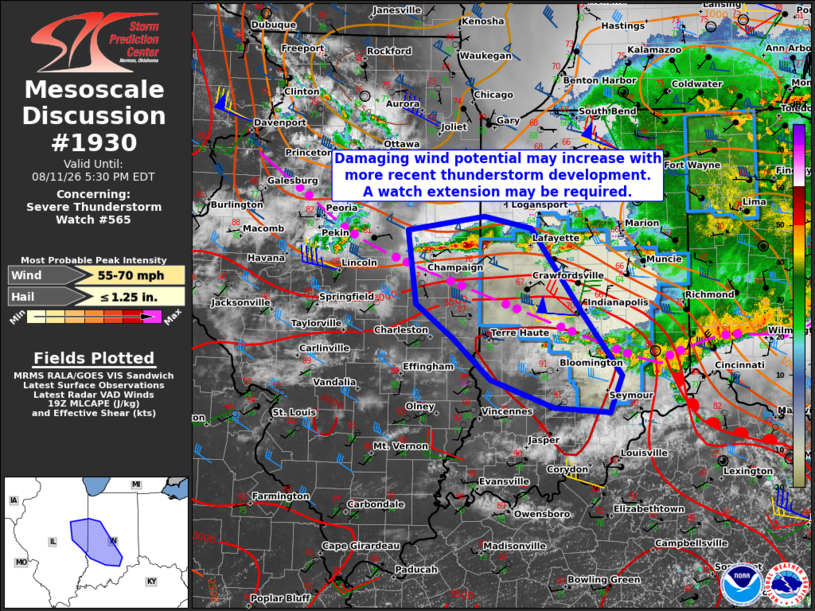
Mesoscale Discussion 1930 NWS Storm Prediction Center Norman OK 0228 PM CDT Tue Aug 11 2026 Areas affected...east-central Illinois into west-central and southern Indiana Concerning...Severe Thunderstorm Watch 565... Valid 111928Z - 112130Z The severe weather threat for Severe Thunderstorm Watch 565 continues. SUMMARY...Damaging wind potential may increase with more recent thunderstorm development, which would potentially require an extension of the watch into portions of southwest Indiana. DISCUSSION...A west-to-east-oriented band of thunderstorms has recently intensified across portions of east-central IL into west-central IN, to the north of an outflow boundary from earlier convection. The 18Z ILX sounding is likely representative of the inflow environment with steep mid-level lapse rates and a moist boundary layer yielding MLCAPE of 2000-2500 J/kg. The current storms might still be slightly elevated atop a shallow surface inversion. However, a continued storm motion toward the more unstable environment should support a transition to surface-based updrafts with an increasing threat for damaging wind gusts as the attending cold pool matures. Prior to that, isolated occurrences of severe hail are possible. The severe threat is expected to largely spread southeast into the watch area over the next hour, so an additional watch to the west in IL is not currently anticipated. However, the current watch may need to be locally extended into southwest IN. ..Mead.. 08/11/2026 ...Please see www.spc.noaa.gov for graphic product... ATTN...WFO...LMK...IWX...IND...LOT...ILX... LAT...LON 39828835 40558847 40708746 40588685 39728618 39098568 38728585 38788656 39058739 39478786 39828835 MOST PROBABLE PEAK WIND GUST...55-70 MPH MOST PROBABLE PEAK HAIL SIZE...UP TO 1.25 IN |
|
|
Top/All Mesoscale Discussions/Forecast Products/Home |
|
Source link