

| Mesoscale Discussion 1925 | |
| < Previous MD | |

|
|
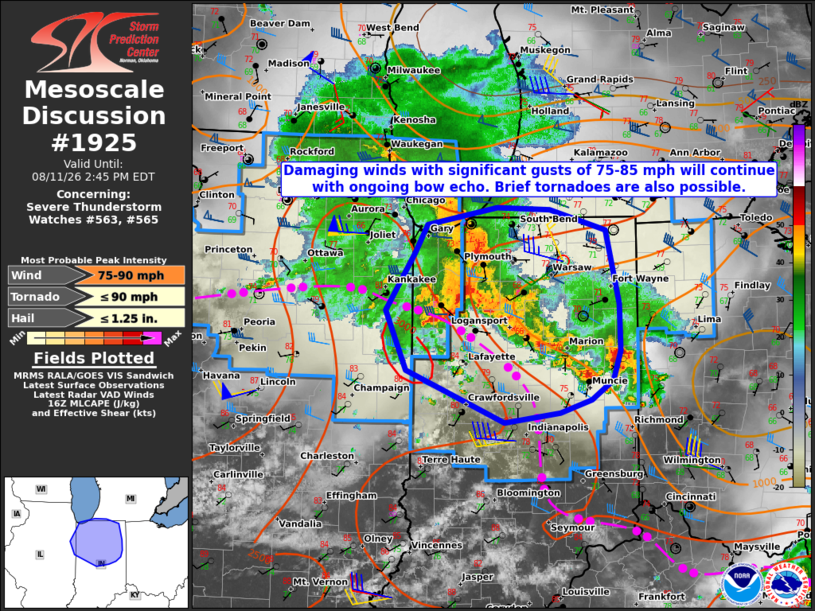
Mesoscale Discussion 1925 NWS Storm Prediction Center Norman OK 1142 AM CDT Tue Aug 11 2026 Areas affected...northeast Illinois into far southwest lower Michigan and northern and central Indiana Concerning...Severe Thunderstorm Watch 563...565... Valid 111642Z - 111845Z The severe weather threat for Severe Thunderstorm Watch 563, 565 continues. SUMMARY...Damaging winds with significant gusts up to 75-85 mph are expected to continue with the ongoing bow echo. Brief tornadoes are also possible. DISCUSSION...An intense bow echo with a history of 85-95+ mph wind gusts across Chicagoland has shifted into far northwest IN as of 1635Z. System movement is east at 55 to 60 kt. Considerable downstream convection present from the vicinity of the bow echo to north of Muncie has hindered daytime heating and resultant air mass destabilization within the inflow region of the bow echo. Nonetheless, the presence of an organized cold pool with an intense rear-inflow jet will support the continuation of damaging winds with significant gusts up to 75-85 mph for at least the next hour or two across portions of northern IN and perhaps far southwest lower MI. Brief tornadoes are also possible, especially with mesovortices forming near or north of the apex of the bow. Some recent CAM guidance suggests that a longer-duration significant wind threat could materialize within the southern flank of the bow echo and preceding convective band over central into southeast IN. That scenario appears plausible given the influx of a strongly unstable air mass from central IL into the region. ..Mead.. 08/11/2026 ...Please see www.spc.noaa.gov for graphic product... ATTN...WFO...IWX...IND...LOT...ILX... LAT...LON 40898785 41428750 41698735 41848649 41828585 41638518 40958502 40538500 40268510 40088535 39968574 39878640 40358759 40898785 MOST PROBABLE PEAK TORNADO INTENSITY...UP TO 90 MPH MOST PROBABLE PEAK WIND GUST...75-90 MPH MOST PROBABLE PEAK HAIL SIZE...UP TO 1.25 IN |
|
|
Top/All Mesoscale Discussions/Forecast Products/Home |
|
Source link