

| Mesoscale Discussion 1921 | |
| < Previous MD | |

|
|
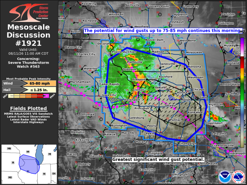
Mesoscale Discussion 1921 NWS Storm Prediction Center Norman OK 0900 AM CDT Tue Aug 11 2026 Areas affected...southern Wisconsin...northern Illinois...and far northwest Indiana Concerning...Severe Thunderstorm Watch 563... Valid 111400Z - 111600Z The severe weather threat for Severe Thunderstorm Watch 563 continues. SUMMARY...The potential for significant wind gusts up to 75-85 mph is expected to persist with an evolving bow echo this morning. DISCUSSION...An MCS with a history of producing wind gusts of 70-80 mph is currently evolving into a broader bowing configuration over east-central IA and far northwest IL as of 1355Z. The 12z DVN sounding is likely a good representation of the ambient inflow environment, featuring steep mid-level lapse rates and abundant boundary-layer moisture, yielding MUCAPE of 4500-5000 J/kg. A largely unidirectional wind profile with around 35 kt of deep-layer shear (per the 12z DVN sounding and current VWP) in conjunction with the strongly unstable environment is likely to support further intensification of the bow echo with an associated risk for significant wind gusts up to 75-85 mph. Around 30 kt of 0-3 km shear oriented largely perpendicular to the cold pool may support some tornado potential, especially where the low-level shear and cold pool remain in balance. The bow echo is expected to track along a residual outflow boundary from a downstream MCS, which extends east-southeast through the south side of the greater Chicago metropolitan area into far northwest IN. ..Mead.. 08/11/2026 ...Please see www.spc.noaa.gov for graphic product... ATTN...WFO...LOT...ILX...MKX...DVN...ARX... LAT...LON 41019100 41759134 42869123 43259046 42988895 42728791 42168727 41348703 40718724 40268791 40358868 41019100 MOST PROBABLE PEAK WIND GUST...65-80 MPH MOST PROBABLE PEAK HAIL SIZE...UP TO 1.25 IN |
|
|
Top/All Mesoscale Discussions/Forecast Products/Home |
|
Source link