

| Mesoscale Discussion 1916 | |
| < Previous MD | |

|
|
   Mesoscale Discussion 1916
   NWS Storm Prediction Center Norman OK
   1030 PM CDT Mon Aug 10 2026

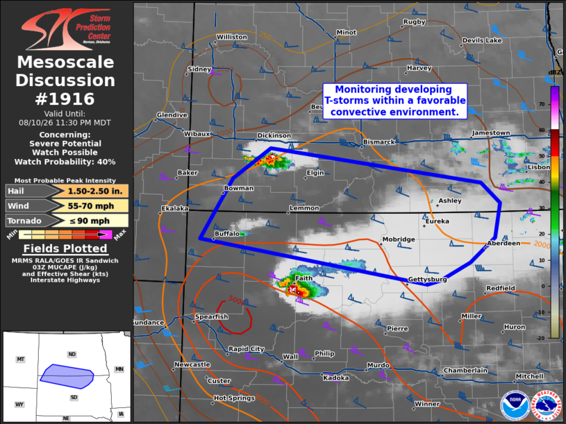
   Areas affected...Southwest North Dakota into northern South Dakota

   Concerning...Severe potential...Watch possible

   Valid 110330Z - 110530Z

   Probability of Watch Issuance...40 percent

   SUMMARY...Elevated convection developing across southwest North
   Dakota may continue to intensify and pose a severe threat over the
   next few hours, though confidence in exact evolution is uncertain.

   DISCUSSION...Convection has been gradually intensifying to the west
   of Bismarck, ND over the past 45 minutes, and a few additional
   updrafts are noted to the southwest of this cell per GOES IR
   imagery. This activity appears to be driven by weak ascent within a
   diffuse low-level baroclinic zone draped from southwest ND
   southeastward into SD based on recent upper-air analyses. Although
   this activity is somewhat displaced to the north of the axis of
   greater buoyancy (and is upstream of the cold pool associated with a
   leading supercell in SD), the 00 UTC BIS RAOB and recent forecast
   soundings suggest buoyancy should be adequate for sustained deep
   convection downstream into south-central ND. Additionally, strong
   deep-layer shear remains in place across the region and can support
   intense supercell development (as evident by the aforementioned
   supercell in SD, which matured in a similar kinematic environment).
   Despite the favorable convective environment, it remains unclear
   whether this emerging cell will remain isolated or if additional
   convection will emerge within this zone and foster upscale growth
   along the baroclinic zone into SD later tonight. Convective trends
   will continue to be monitored, and watch issuance may be needed as
   dictated by storm evolution and intensity.

   ..Moore/Mosier.. 08/11/2026

   ...Please see www.spc.noaa.gov for graphic product...

   ATTN...WFO...ABR...BIS...UNR...

   LAT...LON   45570379 46380319 46770250 46329853 46049819 45599830
               45289877 45059933 44999957 45570379

   MOST PROBABLE PEAK TORNADO INTENSITY...UP TO 90 MPH
   MOST PROBABLE PEAK WIND GUST...55-70 MPH
   MOST PROBABLE PEAK HAIL SIZE...1.50-2.50 IN
|
|
|
Top/All Mesoscale Discussions/Forecast Products/Home |
|
Source link