

| Mesoscale Discussion 1911 | |
| < Previous MD | |

|
|
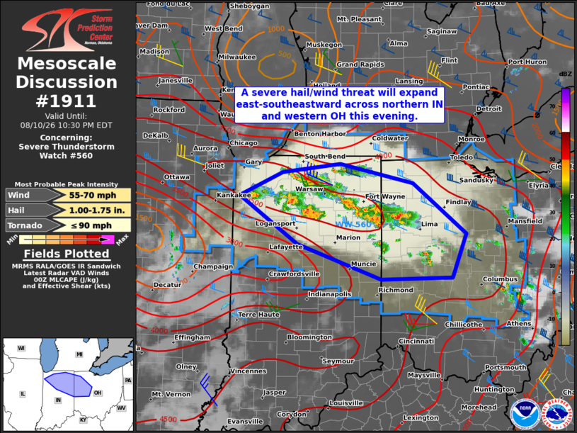
Mesoscale Discussion 1911 NWS Storm Prediction Center Norman OK 0800 PM CDT Mon Aug 10 2026 Areas affected...Parts of northern IN into western OH Concerning...Severe Thunderstorm Watch 560... Valid 110100Z - 110230Z The severe weather threat for Severe Thunderstorm Watch 560 continues. SUMMARY...A severe hail/wind threat will expand east-southeastward across northern Indiana into western Ohio this evening. DISCUSSION...Thunderstorms have increased in coverage this evening across northern IN, likely aided by a weak mid-level disturbance noted on water vapor satellite imagery upstream across IL. Initial cells have undergone mergers, with multiple clusters ongoing. Ample low-level moisture and related very strong buoyancy will continue to support vigorous updrafts, even though stronger mid-level flow and related deep-layer shear will tend to remain a bit displaced to the north of the surface warm sector. Even so, enough shear should be present to support a mix of supercells and multicells in the short term (reference recent VWPs from KIWX). Severe hail generally up to 1-1.5 inches in diameter will be possible with any cells that can remain at least semi-discrete, while damaging winds may occur with any small clusters moving east-southeastward. An increase in the severe wind potential may develop across parts of northeast IN into northwest OH if a more dominant cluster can become established, as some short-term guidance suggests. ..Gleason.. 08/11/2026 ...Please see www.spc.noaa.gov for graphic product... ATTN...WFO...CLE...ILN...IWX...IND...LOT... LAT...LON 41528662 41648555 41388421 40668325 40058350 40048481 40538634 41198741 41528662 MOST PROBABLE PEAK TORNADO INTENSITY...UP TO 90 MPH MOST PROBABLE PEAK WIND GUST...55-70 MPH MOST PROBABLE PEAK HAIL SIZE...1.00-1.75 IN |
|
|
Top/All Mesoscale Discussions/Forecast Products/Home |
|
Source link