

| Mesoscale Discussion 1905 | |
| < Previous MD | |

|
|
   Mesoscale Discussion 1905
   NWS Storm Prediction Center Norman OK
   0515 PM CDT Mon Aug 10 2026

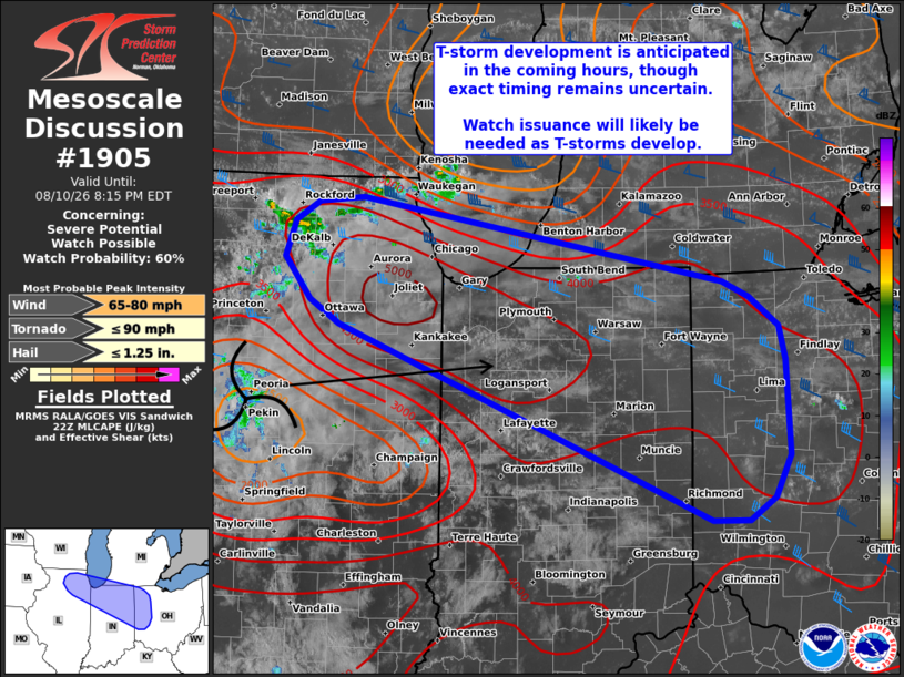
   Areas affected...Northern Illinois into northern Indiana and western
   Ohio

   Concerning...Severe potential...Watch possible

   Valid 102215Z - 110015Z

   Probability of Watch Issuance...60 percent

   SUMMARY...Thunderstorm development is anticipated in the coming
   hours across northern Indiana and western Ohio. Although timing
   remains uncertain based on latest satellite trends, watch issuance
   will likely be needed given a favorable convective environment for
   severe thunderstorms.

   DISCUSSION...Air mass recovery has been ongoing across IN and
   western OH in the wake of convection earlier today with temperatures
   warming well into the mid to upper 80s and dewpoints increasing into
   the mid 70s. This low-level destabilization, combined with eastward
   advection of steeper mid-level lapse rates, are supporting a
   corridor of extreme buoyancy with MLCAPE values estimated to be
   between 4000-5000 J/kg.

   Upstream, a subtle mid-level vorticity maximum is noted across
   central IL has been supporting weak convection across northern IL
   over the past few hours. Additional thunderstorm development appears
   likely as ascent associated with this weak disturbance spreads east
   towards the buoyancy axis. Although the region remains on the
   southern periphery of a 40-50 knot mid-level jet, regional VWPs show
   25-30 knot flow between 5-7 km, which is supporting adequate
   hodograph elongation for effective bulk shear values on the order of
   25-35 knots - sufficient for organized convection, including a few
   supercells.

   Exact timing of when robust/intense convection develops remains
   uncertain with latest GOES imagery showing limited vertical growth
   of low-level cumulus. Additionally, recent high-res solutions also
   shows disparity regarding the timing of convective initiation.
   Regardless, watch issuance will likely be required once thunderstorm
   initiation becomes apparent given the favorable convective
   environment.

   ..Moore/Mosier.. 08/10/2026

   ...Please see www.spc.noaa.gov for graphic product...

   ATTN...WFO...CLE...ILN...IWX...IND...LOT...

   LAT...LON   41288866 41488898 41828925 42138914 42288889 42328840
               41648446 41508416 41268385 40988378 40198374 39848391
               39668419 39658459 41288866

   MOST PROBABLE PEAK TORNADO INTENSITY...UP TO 90 MPH
   MOST PROBABLE PEAK WIND GUST...65-80 MPH
   MOST PROBABLE PEAK HAIL SIZE...UP TO 1.25 IN
|
|
|
Top/All Mesoscale Discussions/Forecast Products/Home |
|
Source link