

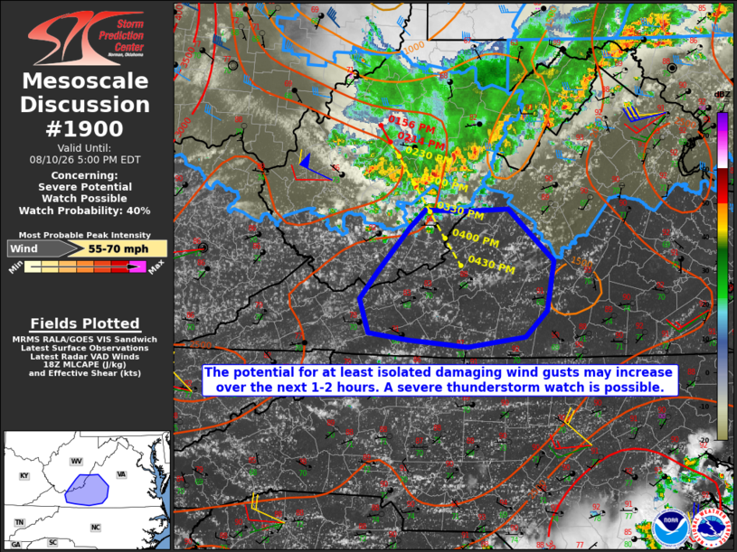
| Mesoscale Discussion 1900 | |
| < Previous MD | |

|
|
   Mesoscale Discussion 1900
   NWS Storm Prediction Center Norman OK
   0200 PM CDT Mon Aug 10 2026

   Areas affected...southeast West Virginia into western Virginia

   Concerning...Severe potential...Watch possible

   Valid 101900Z - 102100Z

   Probability of Watch Issuance...40 percent

   SUMMARY...The potential for at least isolated damaging wind gusts
   may increase over the next one to two hours. Convective trends are
   being monitored for a possible severe thunderstorm watch.

   DISCUSSION...A line of thunderstorms over central WV has recently
   shown a weakened trend, per volumetric radar data, with the
   associated cold pool moving south-southeast at 40-45 kt. Additional
   showers and thunderstorms are developing ahead of the gust front,
   and it's possible that activity could reinforce the cold pool,
   leading to the re-intensification of the thunderstorm line. That
   process may be aided by stronger heating across the downstream air
   mass where objective analysis indicates comparatively steeper
   low-level lapse rates with MLCAPE of 1500-2000 J/kg.

   Given the above considerations, the threat for at least isolated
   damaging wind gusts may increase over the next 1-2 hours. However,
   it's unclear whether sufficient storm organization will occur to
   warrant a severe thunderstorm watch.

   ..Mead/Hart.. 08/10/2026

   ...Please see www.spc.noaa.gov for graphic product...

   ATTN...WFO...RNK...

   LAT...LON   37418112 37838072 38018052 38018001 38037949 37507891
               37017900 36757928 36647999 36718073 36798124 37128135
               37418112

   MOST PROBABLE PEAK WIND GUST...55-70 MPH
|
|
|
Top/All Mesoscale Discussions/Forecast Products/Home |
|
Source link