

| Mesoscale Discussion 1898 | |
| < Previous MD | |

|
|
   Mesoscale Discussion 1898
   NWS Storm Prediction Center Norman OK
   1247 PM CDT Mon Aug 10 2026

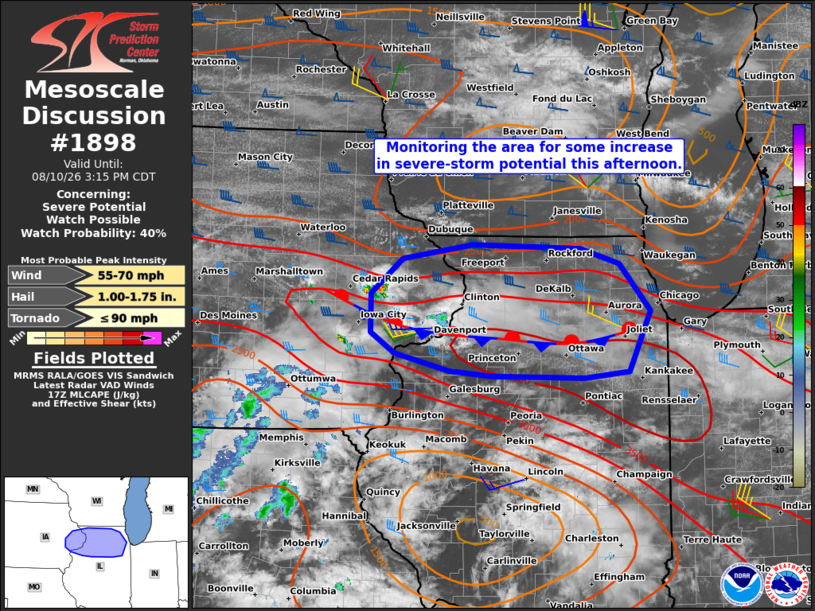
   Areas affected...Far east-central IA and northern IL

   Concerning...Severe potential...Watch possible

   Valid 101747Z - 102015Z

   Probability of Watch Issuance...40 percent

   SUMMARY...Portions of far east-central Iowa into northern Illinois
   are being monitored for some increase in severe-thunderstorm
   potential this afternoon. If sustained storms can evolve, severe
   wind gusts and large hail will both be possible.

   DISCUSSION...The latest surface analysis and visible satellite
   imagery indicate a W/E-oriented stationary boundary extending from
   east-central IA across northern IL. The earlier 12Z ILX sounding
   sampled robust capping at the base of the EML, though temperatures
   are warming into the lower/middle 80s amid upper 70s dewpoints, and
   continued heating should further erode inhibition. Steep midlevel
   lapse rates accompanying the EML atop the rich PBL moisture is
   yielding strong to locally extreme surface-based buoyancy along the
   boundary. Isolated thunderstorms are evolving along the boundary in
   far east-central IA, where surface convergence is maximized. While
   remaining inhibition and generally weak large-scale forcing for
   ascent cast uncertainty on the longevity of this activity and the
   development of additional storms this afternoon, the aforementioned
   buoyancy and around 30-40 kt of effective shear will conditionally
   support organized storms including supercells.

   Any sustained storms will pose a risk of large hail and severe wind
   gusts. Currently, confidence in sustained storms is highest over
   eastern IA and vicinity, where some influence of large-scale forcing
   for ascent preceding an approaching midlevel wave is evident. The
   need for a watch is uncertain, though convective and environmental
   trends are being monitored.

   ..Weinman/Hart.. 08/10/2026

   ...Please see www.spc.noaa.gov for graphic product...

   ATTN...WFO...LOT...ILX...DVN...

   LAT...LON   41148980 41199035 41359106 41569136 41939136 42289095
               42419004 42388864 42238813 41778774 41178801 41118859
               41148980

   MOST PROBABLE PEAK TORNADO INTENSITY...UP TO 90 MPH
   MOST PROBABLE PEAK WIND GUST...55-70 MPH
   MOST PROBABLE PEAK HAIL SIZE...1.00-1.75 IN
|
|
|
Top/All Mesoscale Discussions/Forecast Products/Home |
|
Source link