

| Mesoscale Discussion 1897 | |
| < Previous MD | |

|
|
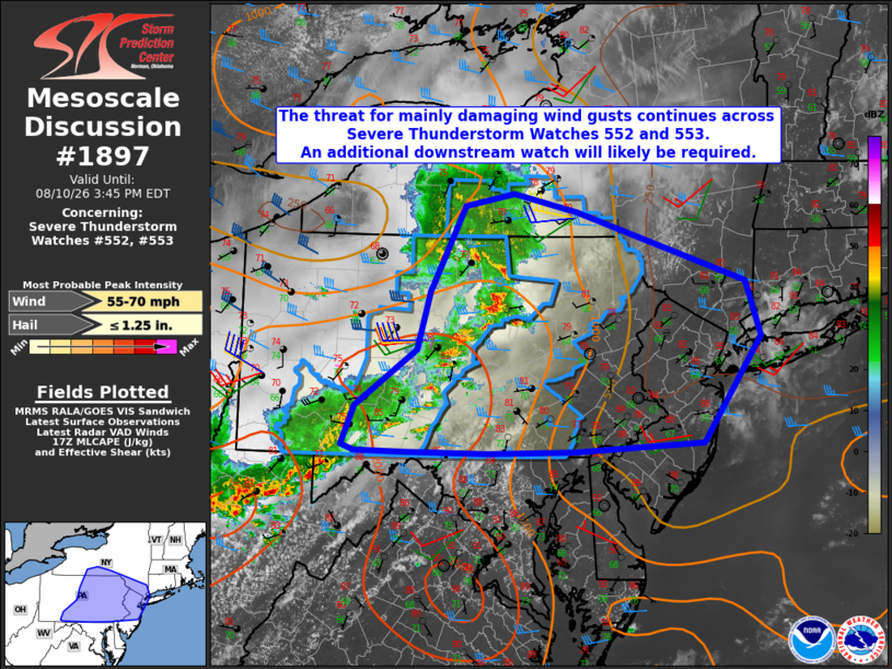
Mesoscale Discussion 1897 NWS Storm Prediction Center Norman OK 1238 PM CDT Mon Aug 10 2026 Areas affected...south-central New York into portions of central and eastern Pennsylvania Concerning...Severe Thunderstorm Watch 552...553... Valid 101738Z - 101945Z The severe weather threat for Severe Thunderstorm Watch 552, 553 continues. SUMMARY...The threat for mainly damaging winds is expected to increase from central into eastern Pennsylvania and locations farther east. An additional downstream watch will likely be required. DISCUSSION...A transition from a line into more cellular convection has occurred over the past 1-2 hours from the vicinity of an MCV over north-central PA into central PA. Storm mode and poor low-level lapse rates have limited damaging wind potential thus far with the cellular convection. With time, coalescing storm-scale cold pools, 40 kt of westerly deep-layer shear, and continued heating/ destabilization of the inflow air mass should support increasing damaging wind potential from central into eastern PA, and eventually NJ and the lower Hudson Valley. As such, a downstream severe thunderstorm watch will likely be required. ..Mead/Hart.. 08/10/2026 ...Please see www.spc.noaa.gov for graphic product... ATTN...WFO...OKX...ALY...PHI...BGM...CTP... LAT...LON 40227896 40827812 41417794 41947767 42317747 42437681 42257593 41537363 40957343 39857422 39777597 39747716 39757827 39767896 39837912 40227896 MOST PROBABLE PEAK WIND GUST...55-70 MPH MOST PROBABLE PEAK HAIL SIZE...UP TO 1.25 IN |
|
|
Top/All Mesoscale Discussions/Forecast Products/Home |
|
Source link