

| Mesoscale Discussion 1886 | |
| < Previous MD | |

|
|
   Mesoscale Discussion 1886
   NWS Storm Prediction Center Norman OK
   0814 PM CDT Sun Aug 09 2026

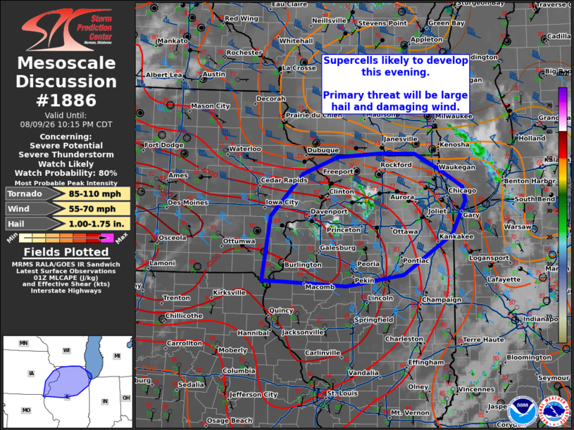
   Areas affected...eastern Iowa into northern Illinois

   Concerning...Severe potential...Severe Thunderstorm Watch likely

   Valid 100114Z - 100315Z

   Probability of Watch Issuance...80 percent

   SUMMARY...Supercells are likely to develop across eastern Iowa into
   northern Illinois this evening. Primary threat will be for large
   hail and damaging wind.

   DISCUSSION...A southwesterly low-level jet (LLJ) around 30-35 kts
   will move into portions of northern Illinois this evening. A surface
   boundary extends across northern Illinois. Near the boundary and
   the nose of the LLJ, there is good run to run agreement in CAM
   guidance that storms will develop across some portion of far eastern
   Iowa into northern Illinois within the warm advection regime this
   evening. Some radar returns and cloud cooling have been noted in the
   last 30 minutes across this area. The environment across this region
   is strongly unstable, with MLCAPE around 2000-4000 J/kg sampled by
   00z RAOBs from DVN and ILX. Deep layer shear around 35-40 kts will
   increase with the LLJ later this evening. This regime will support
   supercells with the primary threat of large hail and damaging wind.
   For any supercell that can remain rooted in the surface, a tornado
   will be possible. A watch will likely be needed to cover this
   potential in the next couple of hours.

   ..Thornton/Mosier.. 08/10/2026

   ...Please see www.spc.noaa.gov for graphic product...

   ATTN...WFO...LOT...ILX...MKX...DVN...

   LAT...LON   40499156 41529139 42199070 42478996 42538906 42528832
               42258779 41988732 41768725 41238754 40598858 40408979
               40479114 40499156

   MOST PROBABLE PEAK TORNADO INTENSITY...85-110 MPH
   MOST PROBABLE PEAK WIND GUST...55-70 MPH
   MOST PROBABLE PEAK HAIL SIZE...1.00-1.75 IN
|
|
|
Top/All Mesoscale Discussions/Forecast Products/Home |
|
Source link