

| Mesoscale Discussion 1884 | |
| < Previous MD | |

|
|
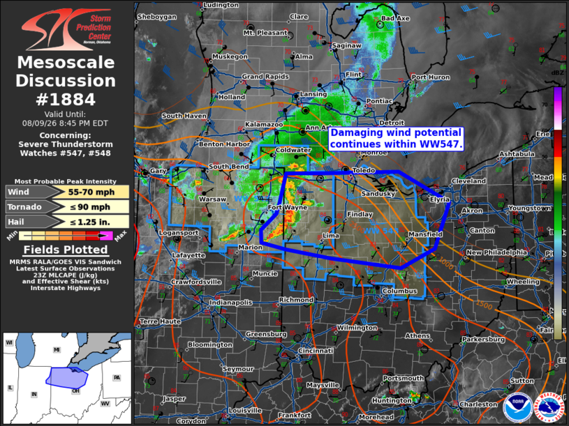
Mesoscale Discussion 1884 NWS Storm Prediction Center Norman OK 0622 PM CDT Sun Aug 09 2026 Areas affected...northern Indiana into northeastern Ohio Concerning...Severe Thunderstorm Watch 547...548... Valid 092322Z - 100045Z The severe weather threat for Severe Thunderstorm Watch 547, 548 continues. SUMMARY...Damaging wind potential continues within WW547. DISCUSSION...A bowing segment continues eastward across northern Indiana, with recent wind gusts to 67 mph reported near Fort Wayne, IN. KIWX radar continues to sample winds around 60 kts around 2 kft. Initial outflow has rushed out ahead of the main line, with additional thunderstorm development ongoing ahead of the line near the outflow. Storms have become better oriented with the mean flow/deep layer shear, which may help aid downstream organization. The greater buoyancy is located across southern/central Ohio. It seems most likely that the southern portion of the line will continue to evolve along this gradient into portions of Ohio with continued damaging wind gusts 60-70 mph downstream for the next couple of hours before outrunning better buoyancy. ..Thornton.. 08/09/2026 ...Please see www.spc.noaa.gov for graphic product... ATTN...WFO...CLE...ILN...IWX... LAT...LON 41688397 41678477 41278487 41108493 40888521 40708521 40618475 40488392 40358263 40618200 41268171 41708266 41688397 MOST PROBABLE PEAK TORNADO INTENSITY...UP TO 90 MPH MOST PROBABLE PEAK WIND GUST...55-70 MPH MOST PROBABLE PEAK HAIL SIZE...UP TO 1.25 IN |
|
|
Top/All Mesoscale Discussions/Forecast Products/Home |
|
Source link