

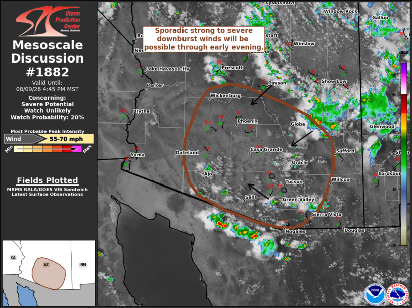
| Mesoscale Discussion 1882 | |
| < Previous MD | |

|
|
   Mesoscale Discussion 1882
   NWS Storm Prediction Center Norman OK
   0447 PM CDT Sun Aug 09 2026

   Areas affected...Southern Arizona

   Concerning...Severe potential...Watch unlikely

   Valid 092147Z - 092345Z

   Probability of Watch Issuance...20 percent

   SUMMARY...Isolated to widely scattered thunderstorms will likely
   spread across southern Arizona through the late afternoon/evening
   hours. Watch issuance is not anticipated given the fairly modest
   kinematic environment, though a few severe downbursts appear
   possible.

   DISCUSSION...Latest GOES imagery and lightning data show the onset
   of deep convection both along the Mogollon Rim and within the higher
   terrain of southern/southeast AZ. Although this activity has been
   slow to move off the terrain so far, modest easterly flow through
   much of the column, combined with cold-pool propagation, should
   promote thunderstorms spreading westward over the next several
   hours. As this occurs, convection will begin to impinge on a very
   deeply mixed, but buoyant, air mass characterized by MLCAPE values
   of around 500-1000 J/kg and 40-45 F dewpoint depressions (which
   suggest LCL heights are around 3 to 3.5 km). This thermodynamic
   profile is very conducive for accelerating downdrafts capable of
   producing swaths of strong to severe winds (possibly as high as
   55-70 mph) within the more intense downbursts.

   Although a favorable thermodynamic environment is in place, the
   observed wind profiles from regional VWPs show meager deep-layer
   wind shear with 0-6 km BWD values of around 15 knots - somewhat
   weaker than the 20-25 knots depicted by RAP mesoanalyses and recent
   HRRR solutions. Consequently, the expectation is for sporadic strong
   to severe downburst winds within poorly organized cells and clusters
   through at least early evening. This activity should remain
   sufficiently transient and isolated to preclude the need for a
   watch.

   ..Moore/Mosier.. 08/09/2026

   ...Please see www.spc.noaa.gov for graphic product...

   ATTN...WFO...TWC...FGZ...PSR...

   LAT...LON   34221182 33871089 33631037 33330996 33110976 32580974
               32000993 31681014 31421048 31351074 31371107 31471155
               31721234 32001296 32251317 32641331 33131330 33801302
               33991290 34171273 34271225 34221182

   MOST PROBABLE PEAK WIND GUST...55-70 MPH
|
|
|
Top/All Mesoscale Discussions/Forecast Products/Home |
|
Source link