

| Mesoscale Discussion 1877 | |
| < Previous MD | |
|
|
   Mesoscale Discussion 1877
   NWS Storm Prediction Center Norman OK
   0920 AM CDT Sun Aug 09 2026

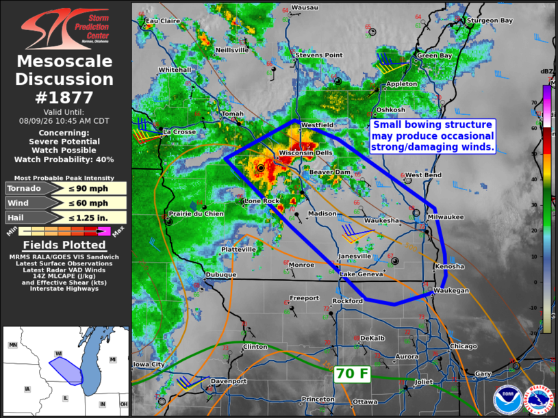
   Areas affected...Portions of southern Wisconsin into far northern
   Illinois

   Concerning...Severe potential...Watch possible

   Valid 091420Z - 091545Z

   Probability of Watch Issuance...40 percent

   SUMMARY...An organized bowing structure, likely elevated at present
   time, could become near surface based as it moves into southeastern
   Wisconsin and adjacent northern Illinois. Wind damage would be the
   main threat. A watch is possible should observational trends
   warrant.

   DISCUSSION...A small bowing cluster has been moving southeastward
   this morning. This activity has remained elevated thus far, but the
   airmass ahead of it is slowly destabilizing. Dewpoints in northern
   Illinois/southern Wisconsin have increased over the past couple of
   hours. The main limiter in terms of destabilization has been the
   cloud cover/smoke that has reduced insolation. Based on forecast
   soundings, if temperatures can reach the mid 70s F the storms will
   be at least near surface based. Given the current organization of
   ongoing convection, there may be an increase in damaging wind
   potential over the next couple of hours. The need for a watch is
   uncertain and will depend on observation trends.

   ..Wendt/Hart.. 08/09/2026

   ...Please see www.spc.noaa.gov for graphic product...

   ATTN...WFO...LOT...MKX...ARX...

   LAT...LON   42338865 42578899 43008959 43609043 43968955 43808901
               43158779 42748767 42538767 42418772 42278830 42338865

   MOST PROBABLE PEAK TORNADO INTENSITY...UP TO 90 MPH
   MOST PROBABLE PEAK WIND GUST...UP TO 60 MPH
   MOST PROBABLE PEAK HAIL SIZE...UP TO 1.25 IN
|
|
|
Top/All Mesoscale Discussions/Forecast Products/Home |
|
Source link