

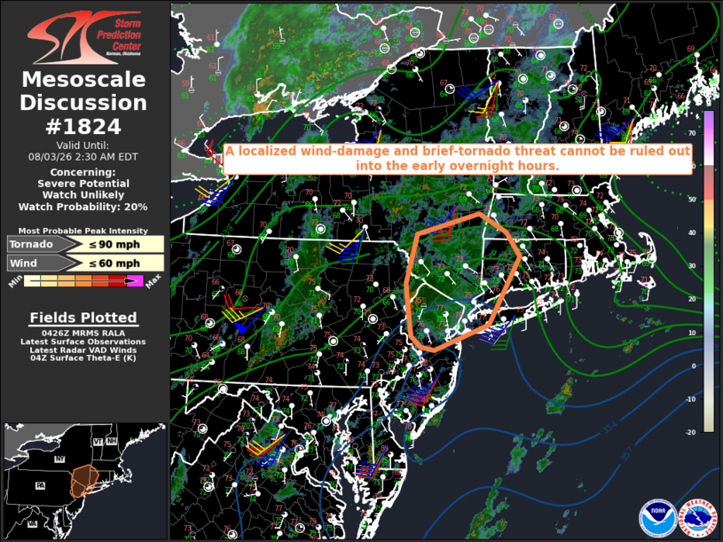
| Mesoscale Discussion 1824 | |
| < Previous MD | |

|
|
   Mesoscale Discussion 1824
   NWS Storm Prediction Center Norman OK
   1129 PM CDT Sun Aug 02 2026

   Areas affected...Eastern PA into parts of the Hudson Valley and
   vicinity

   Concerning...Severe potential...Watch unlikely

   Valid 030429Z - 030630Z

   Probability of Watch Issuance...20 percent

   SUMMARY...A localized wind-damage and brief-tornado threat cannot be
   ruled out into the early overnight hours.

   DISCUSSION...A long-lived but generally sub-severe storm cluster is
   currently moving toward eastern PA, with another area of convection
   gradually developing from eastern PA toward the Hudson Valley,
   within a low-level warm-advection regime associated with a mid/upper
   trough extending from Quebec into the OH/TN Valleys and Southeast. A
   surface low is centered near Lake Erie, with a surface trough
   extending south-southwestward from the surface low into the
   central/southern Appalachians. The surface low/trough will gradually
   shift eastward into the overnight hours, while the preceding
   low-level theta-e advection will expand across the Hudson Valley
   into parts of southern New England.

   Lapse rates are generally poor across the region (generally 6 C/km
   or less through most of the troposphere), which will continue to
   limit updraft intensity. However, rich boundary-layer moisture and
   gradually strengthening low-level SRH (as depicted in regional VWPs
   from KDIX and KOKX) may allow for transient storm organization and
   rotation into the early overnight hours, with a localized threat of
   a brief tornado and/or localized damaging gusts.

   ..Dean/Hart.. 08/03/2026

   ...Please see www.spc.noaa.gov for graphic product...

   ATTN...WFO...BOX...OKX...ALY...PHI...BGM...

   LAT...LON   40537499 41017506 41347509 42117487 42447357 42147302
               41767274 40717339 40317450 40357478 40537499

   MOST PROBABLE PEAK TORNADO INTENSITY...UP TO 90 MPH
   MOST PROBABLE PEAK WIND GUST...UP TO 60 MPH
|
|
|
Top/All Mesoscale Discussions/Forecast Products/Home |
|
Source link