

| Mesoscale Discussion 1815 | |
| < Previous MD | |

|
|
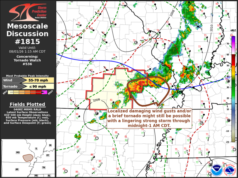
Mesoscale Discussion 1815 NWS Storm Prediction Center Norman OK 1109 PM CDT Fri Jul 31 2026 Areas affected...parts of southeastern Missouri Concerning...Tornado Watch 536... Valid 010409Z - 010615Z The severe weather threat for Tornado Watch 536 continues. SUMMARY...Localized damaging wind gusts and/or a brief tornado may still be possible with an evolving storm northwest through north of Poplar Bluff through midnight-1 AM CDT. DISCUSSION...Downstream of the notable short wave trough digging into the middle Mississippi Valley, lingering thunderstorm development has been tending to spread east of a narrowing pre-cold frontal instability axis supported by mid/upper 70s F surface dew points. Even with surface dew points only gradually decreasing through the lower 70s to the east of this axis, forecast soundings indicate that CAPE becomes increasingly modest, with near-surface buoyancy becoming negligible. As one strong cell, with an evolving broad low-level cyclonic circulation, increasingly encountered this environment to the east of the Farmington vicinity it has tended to substantively weaken. A trailing vigorous upstream cell seems likely to do the same within the next hour or two, to the west/southwest of Cape Girardeau. Until then though, some further intensification and organization might still be possible in the near term to the northwest through north of Poplar Bluff, perhaps accompanied by locally damaging wind gusts or a brief tornado. ..Kerr.. 08/01/2026 ...Please see www.spc.noaa.gov for graphic product... ATTN...WFO...PAH...LSX...SGF... LAT...LON 37449082 37519008 37128968 36639013 36719018 36649083 37279131 37449082 MOST PROBABLE PEAK TORNADO INTENSITY...UP TO 90 MPH MOST PROBABLE PEAK WIND GUST...55-70 MPH |
|
|
Top/All Mesoscale Discussions/Forecast Products/Home |
|
Source link