

| Mesoscale Discussion 1813 | |
| < Previous MD | |

|
|
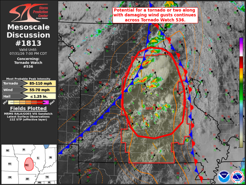
Mesoscale Discussion 1813 NWS Storm Prediction Center Norman OK 0530 PM CDT Fri Jul 31 2026 Areas affected...portions of central and eastern Missouri Concerning...Tornado Watch 536... Valid 312230Z - 010000Z The severe weather threat for Tornado Watch 536 continues. SUMMARY...The potential for a tornado or two and damaging wind gusts continues across portions of Tornado Watch 536. DISCUSSION...Scattered thunderstorms have developed along/ahead of a southeastward-progressing surface cold front and accompanying pre-frontal confluence zone over the past 1-2 hours in central Missouri. Continued northeasterly advection of higher theta-e air within the narrow warm sector is supporting MLCAPE values of 1500-2500+ J/kg and 0-3 km CAPE of 100+ J/kg per latest mesoanalysis. Surface dewpoints in the mid/upper 70s F, low LCLs, and a corridor of enhanced low-level shear (200 m2/s2 0-1 km SRH sampled by the LSX VWP) will continue to promote a risk for a tornado or two along with damaging wind gusts as convection progresses east-southeastward over the next 1-2 hours. The greatest potential is likely to accompany any storm that can favorably interact with a surface stationary/warm frontal boundary currently analyzed near the MO/IL border and the more backed surfaced winds noted in closer proximity to this boundary. ..Chalmers.. 07/31/2026 ...Please see www.spc.noaa.gov for graphic product... ATTN...WFO...LSX...SGF...EAX... LAT...LON 38249070 37699079 37349120 37219184 37289246 37539271 38159302 38569303 38919293 39409270 39759243 39889201 39859153 39689121 39319099 38669073 38249070 MOST PROBABLE PEAK TORNADO INTENSITY...85-110 MPH MOST PROBABLE PEAK WIND GUST...55-70 MPH MOST PROBABLE PEAK HAIL SIZE...UP TO 1.25 IN |
|
|
Top/All Mesoscale Discussions/Forecast Products/Home |
|
Source link